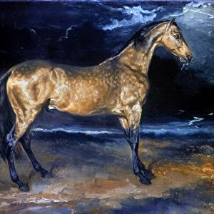
Postcard : A Map of the World, Corrected from the Observations communicated to the Royal Societies of London


Resolution may be poor at this size (81 DPI)
![]()
Cards from Fine Art Finder
A Map of the World, Corrected from the Observations communicated to the Royal Societies of London
XCF291087 A Map of the World, Corrected from the Observations communicated to the Royal Societies of London and Paris, to the Right Honourable Richard Boyle, 1711 (colour engraving) by Senex, John (1678-1740) and Maxwell, John (fl.1710-c.1724); Private Collection; English, out of copyright
Media ID 12793555
© www.bridgemanart.com
Atlantic Eastern Ethiopia Geographical Mapping New Holland North Pacific Ocean South Western Double Hemisphere
Postcards (8 pack of A6)
Set of 8, A6 Postcards, featuring the same image on all cards in a set. Printed on 350gsm premium white satin card, the back of the postcard includes space to write messages and an area for the address and stamp. Size of each postcard is 15cm x 10.6cm.
Photo postcards are a great way to stay in touch with family and friends.
Estimated Product Size is 15cm x 10.6cm (5.9" x 4.2")
These are individually made so all sizes are approximate
Artwork printed orientated as per the preview above, with landscape (horizontal) or portrait (vertical) orientation to match the source image.
EDITORS COMMENTS
This print showcases "A Map of the World, Corrected from the Observations communicated to the Royal Societies of London and Paris" by John Senex and John Maxwell. Created in 1711, this exquisite color engraving is a testament to their expertise in mapping and cartography. The map presents a double hemisphere view, depicting both the eastern and western parts of the world. It offers an intricate representation of various continents, including America, Africa, Asia, and New Holland (now known as Australia). The Pacific Ocean stretches across one side while the Atlantic dominates the other. With meticulous detail, Senex and Maxwell have accurately depicted geographical features such as rivers, mountains, coastlines, and islands. This scientific approach highlights their commitment to precision in cartographic artistry. Notably significant is their inclusion of Ethiopia within Africa's borders—a nod to its historical importance. The Great South Sea also commands attention as it captures explorers' imaginations with its vastness yet uncharted territories. This stunning print invites viewers into a world where knowledge was still being discovered. It serves as a reminder that maps are not merely navigational tools but also works of art that reflect our evolving understanding of our planet's geography throughout history.
MADE IN THE UK
Safe Shipping with 30 Day Money Back Guarantee
FREE PERSONALISATION*
We are proud to offer a range of customisation features including Personalised Captions, Color Filters and Picture Zoom Tools
SECURE PAYMENTS
We happily accept a wide range of payment options so you can pay for the things you need in the way that is most convenient for you
* Options may vary by product and licensing agreement. Zoomed Pictures can be adjusted in the Basket.