Postcard > Arts > Artists > L > Guillaume Le Testu
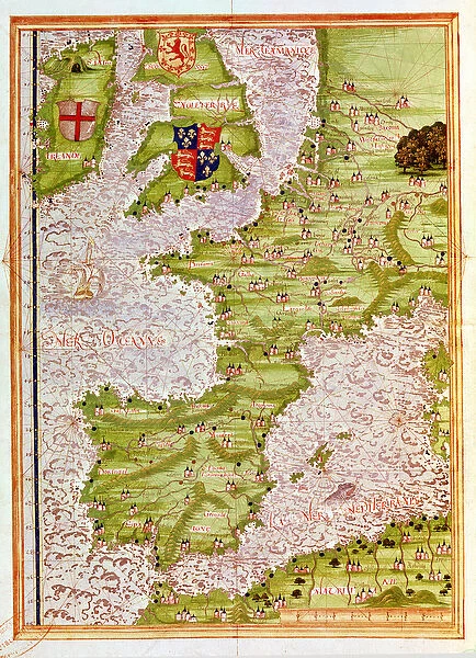
Postcard : Fol. 9v Map of Western Europe, from Cosmographie Universelle, 1555 (w / c
Resolution may be poor at this size (98 DPI)
![]()

Cards from Fine Art Finder
Fol. 9v Map of Western Europe, from Cosmographie Universelle, 1555 (w / c
XIR178715 Fol.9v Map of Western Europe, from Cosmographie Universelle, 1555 (w/c on paper) by Le Testu, Guillaume (c.1509-73); Min. Defense - Service Historique de l Armee de Terre, France; French, out of copyright
Media ID 12701781
© www.bridgemanimages.com
Atlantic Channel Chart Continent Continental Mediterranean North Sea Portugal Sea Monster
Postcards (8 pack of A6)
Set of 8, A6 Postcards, featuring the same image on all cards in a set. Printed on 350gsm premium white satin card, the back of the postcard includes space to write messages and an area for the address and stamp. Size of each postcard is 15cm x 10.6cm.
Photo postcards are a great way to stay in touch with family and friends.
Estimated Product Size is 10.6cm x 15cm (4.2" x 5.9")
These are individually made so all sizes are approximate
Artwork printed orientated as per the preview above, with landscape (horizontal) or portrait (vertical) orientation to match the source image.
FEATURES IN THESE COLLECTIONS
> Fine Art Finder
> Artists
> Guillaume Le Testu
> Arts
> Artists
> L
> Guillaume Le Testu
EDITORS COMMENTS
This print showcases the Fol. 9v Map of Western Europe, a remarkable piece of cartography from 1555. Created by Guillaume Le Testu, a renowned French mapmaker, this watercolor on paper masterpiece offers an intriguing glimpse into the geographical understanding of the time. The map depicts Western Europe with meticulous detail, featuring countries such as England, France, Spain, Portugal, Germany, Ireland, and Scotland. The Mediterranean Sea and Atlantic Ocean dominate the scene while the English Channel and North Sea connect these vast bodies of water. What makes this map truly fascinating are its intricate embellishments. Adorning the borders are various coats of arms representing different regions or noble families. Additionally, hidden within the depths of the sea is a fearsome sea monster that adds an element of mystery to this historical artwork. As we delve into this ancient depiction of Western Europe's geography and cartography, it becomes evident that Le Testu's work was not only informative but also aesthetically pleasing. This Fine Art Finder print allows us to appreciate every minute detail in vibrant colors and exquisite clarity. With its rich history and artistic charm preserved through time by Service Historique de l'Armee de Terre in France, this image serves as a testament to human curiosity about our world's landscapes centuries ago. It invites us to explore not only physical territories but also cultural connections that have shaped our present-day understanding of Western Europe's past.
MADE IN THE UK
Safe Shipping with 30 Day Money Back Guarantee
FREE PERSONALISATION*
We are proud to offer a range of customisation features including Personalised Captions, Color Filters and Picture Zoom Tools
SECURE PAYMENTS
We happily accept a wide range of payment options so you can pay for the things you need in the way that is most convenient for you
* Options may vary by product and licensing agreement. Zoomed Pictures can be adjusted in the Basket.


