Postcard > Fine Art Finder > Maps (celestial & Terrestrial)
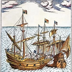
Postcard : A True Description of the Naval Expedition of Francis Drake, who with Five Ships


![]()
Cards from Fine Art Finder
A True Description of the Naval Expedition of Francis Drake, who with Five Ships
XYC148716 A True Description of the Naval Expedition of Francis Drake, who with Five Ships Departed from the Western Part of England on 13th December 1577, Circumnavigated the Globe and Returned on 26th September 1580 with One Ship Remaining, the Others Having been Destroyed by Waves of Fire, c.1587 (pen, ink and wash on vellum) by Drake, Francis (c.1540-96); 23.9x44.9 cm; Yale Center for British Art, Paul Mellon Collection, USA; (add.info.: earliest extant map marking route of Drakes circumnavigation; reduced copy of original given to Elizabeth I and now destroyed; Drakes reception in the Moluccas (Spice Islands); grounding of Golden Hind on reef in the Celebes; St. George flag on Elizabetha - the southernmost island of Tierra del Fuego archipelago; ); English, out of copyright
Media ID 12727284
© www.bridgemanimages.com
Circumnavigation Continent Continents Elizabethan Navigation Navigator Round The World Route Sir Francis Drake
Postcards (8 pack of A6)
Set of 8, A6 Postcards, featuring the same image on all cards in a set. Printed on 350gsm premium white satin card, the back of the postcard includes space to write messages and an area for the address and stamp. Size of each postcard is 15cm x 10.6cm.
Photo postcards are a great way to stay in touch with family and friends.
Estimated Product Size is 15cm x 10.6cm (5.9" x 4.2")
These are individually made so all sizes are approximate
Artwork printed orientated as per the preview above, with landscape (horizontal) or portrait (vertical) orientation to match the source image.
FEATURES IN THESE COLLECTIONS
> Fine Art Finder
> Artists
> Francis Drake
> Fine Art Finder
> Maps (celestial & Terrestrial)
EDITORS COMMENTS
This print showcases "A True Description of the Naval Expedition of Francis Drake" a historic moment captured in pen, ink, and wash on vellum. The artwork depicts the remarkable journey undertaken by Sir Francis Drake and his fleet of five ships. Departing from England's western shores on December 13th, 1577, they embarked on a daring circumnavigation of the globe. The image reveals the awe-inspiring events that unfolded during their expedition. Waves of fire destroyed all but one ship, leaving them with just the resilient Golden Hind upon their triumphant return to England on September 26th, 1580. This reduced copy served as an early map marking Drake's route and was originally presented to Queen Elizabeth I before its unfortunate destruction. Within this intricate illustration lies a visual narrative filled with significant moments. It portrays Drake's warm reception in the Moluccas (Spice Islands), where he encountered new cultures and traded valuable goods. Another scene captures the dramatic grounding of Golden Hind on a reef in Celebes, highlighting both challenges faced and overcome during their voyage. Notably featured is St. George's flag proudly flying atop Elizabetha - the southernmost island within Tierra del Fuego archipelago - symbolizing English exploration reaching distant lands. This extraordinary artwork serves as a testament to Sir Francis Drake's pioneering spirit as an explorer and navigator during the Elizabethan era. Its historical significance is further enhanced by its preservation at Yale Center for British Art within Paul Mellon Collection in America.
MADE IN THE UK
Safe Shipping with 30 Day Money Back Guarantee
FREE PERSONALISATION*
We are proud to offer a range of customisation features including Personalised Captions, Color Filters and Picture Zoom Tools
SECURE PAYMENTS
We happily accept a wide range of payment options so you can pay for the things you need in the way that is most convenient for you
* Options may vary by product and licensing agreement. Zoomed Pictures can be adjusted in the Basket.