Photographic Print > Asia > Pakistan > Maps
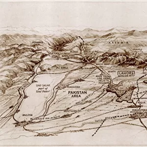
Photographic Print : Proposed partition map of India and Pakistan


![]()
Photo Prints from Mary Evans Picture Library
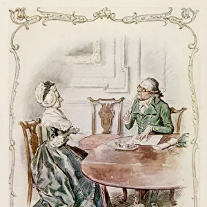
Proposed partition map of India and Pakistan
A map of India showing the suggested area of Pakistan - an independent state for Muslims in a free India. The shaded area shows the provinces forming the basis of Pakistan, as proposed by the Muslim League. Date: 1946
Mary Evans Picture Library makes available wonderful images created for people to enjoy over the centuries
Media ID 14379766
© Illustrated London News Ltd/Mary Evans
1946 Jan16 League Muslim Pakistan Partition Proposed Suggested
10"x8" (25x20cm) Photo Print
Discover history through the lens with our exclusive range of Photographic Prints from Media Storehouse. This captivating image, "Proposed partition map of India and Pakistan" by Rights Managed from Mary Evans Prints Online, offers a fascinating glimpse into the past. The map, showing the proposed areas for an independent Muslim state in India, provides a thought-provoking perspective on the historical events leading to the creation of Pakistan. Each print is meticulously produced using high-quality materials to ensure vibrant colors and sharp details, making it a perfect addition to any home or office. Bring history to life with this intriguing piece of photographic art.
Printed on archival quality paper for unrivalled stable artwork permanence and brilliant colour reproduction with accurate colour rendition and smooth tones. Printed on professional 234gsm Fujifilm Crystal Archive DP II paper. 10x8 for landscape images, 8x10 for portrait images.
Our Photo Prints are in a large range of sizes and are printed on Archival Quality Paper for excellent colour reproduction and longevity. They are ideal for framing (our Framed Prints use these) at a reasonable cost. Alternatives include cheaper Poster Prints and higher quality Fine Art Paper, the choice of which is largely dependant on your budget.
Estimated Product Size is 20.3cm x 25.4cm (8" x 10")
These are individually made so all sizes are approximate
Artwork printed orientated as per the preview above, with portrait (vertical) orientation to match the source image.
FEATURES IN THESE COLLECTIONS
> Asia
> India
> Related Images
> Asia
> Pakistan
> Related Images
> Maps and Charts
> India
> Maps and Charts
> Related Images
EDITORS COMMENTS
This historic map, dated 16th January 1946, represents a pivotal moment in the political evolution of South Asia. The shaded areas on the map depict the proposed partition of India, outlining the regions that were to form the independent Muslim state of Pakistan. The Muslim League, under the leadership of Muhammad Ali Jinnah, had long advocated for a separate homeland for Muslims in undivided India. The partition of India and the creation of Pakistan were the result of years of communal tensions and political negotiations. The idea of a separate Muslim state gained momentum after the Lahore Resolution of 1940, which called for the establishment of an independent state for Muslims in South Asia. The proposed partition map shows the areas that were to become part of Pakistan, with the eastern and western wings separated by the vast expanse of what is now Bangladesh. The provinces of Punjab, Sindh, Balochistan, and North-West Frontier Province were the main areas of focus for the Muslim League, as they had large Muslim populations. The partition of India and the creation of Pakistan in 1947 brought about immense upheaval and tragedy, with millions of Hindus and Muslims displaced from their homes. The division of families, communities, and historical sites was a painful process, one that continues to shape the region's political and social landscape. This map serves as a reminder of the complex history of the Indian subcontinent and the profound impact of the partition on its people. It is a testament to the enduring legacy of the Muslim League and the political vision of its leaders, who sought to create a separate homeland for Muslims in a free India.
MADE IN THE UK
Safe Shipping with 30 Day Money Back Guarantee
FREE PERSONALISATION*
We are proud to offer a range of customisation features including Personalised Captions, Color Filters and Picture Zoom Tools
FREE COLORIZATION SERVICE
You can choose advanced AI Colorization for this picture at no extra charge!
SECURE PAYMENTS
We happily accept a wide range of payment options so you can pay for the things you need in the way that is most convenient for you
* Options may vary by product and licensing agreement. Zoomed Pictures can be adjusted in the Basket.