Photographic Print > Europe > United Kingdom > Scotland > Fife > Falkland
Photographic Print : Falklands War - 1982


![]()
Photo Prints from Mary Evans Picture Library
Falklands War - 1982
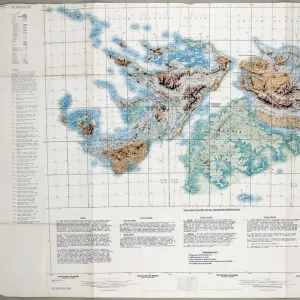
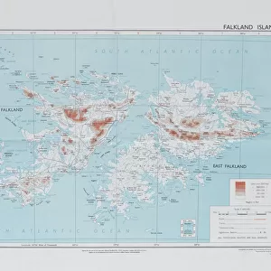
Directorate of Overseas Surveys map of the Falklands Islands, 1983 (c). One of four maps of the Falkland Islands, 1982 (c)-1984 (c). Associated with the South Atlantic (Falklands War), (1982) Date: circa 1860
Mary Evans Picture Library makes available wonderful images created for people to enjoy over the centuries
Media ID 14403821
© The National Army Museum / Mary Evans Picture Library
1982 1983 1984 Associated Atlantic Falkland Falklands Maps Overseas Surveying Surveys Directorate
10"x8" (25x20cm) Photo Print
Introducing the Media Storehouse collection of historic Photographic Prints, featuring the evocative image "Falklands War - 1982" from Mary Evans Prints Online. This powerful photograph captures a Directorate of Overseas Surveys map of the Falkland Islands from 1983, marking the islands and surrounding waters during the pivotal year of 1982. Witness history unfold with this exceptional, rights-managed print, a must-have for history enthusiasts, educators, and collectors alike. Authentically reproduced for lasting quality, each print comes with a certificate of authenticity and is ready to be framed and displayed with pride. Experience the past in vivid detail.
Printed on archival quality paper for unrivalled stable artwork permanence and brilliant colour reproduction with accurate colour rendition and smooth tones. Printed on professional 234gsm Fujifilm Crystal Archive DP II paper. 10x8 for landscape images, 8x10 for portrait images.
Our Photo Prints are in a large range of sizes and are printed on Archival Quality Paper for excellent colour reproduction and longevity. They are ideal for framing (our Framed Prints use these) at a reasonable cost. Alternatives include cheaper Poster Prints and higher quality Fine Art Paper, the choice of which is largely dependant on your budget.
Estimated Product Size is 25.4cm x 20.3cm (10" x 8")
These are individually made so all sizes are approximate
Artwork printed orientated as per the preview above, with landscape (horizontal) or portrait (vertical) orientation to match the source image.
FEATURES IN THESE COLLECTIONS
> Europe
> United Kingdom
> Scotland
> Fife
> Falkland
> Maps and Charts
> Related Images
> South America
> Falkland Islands
> Maps
> South America
> Falkland Islands
> Related Images
EDITORS COMMENTS
This historic map print depicts the Falkland Islands, created by the Directorate of Overseas Surveys in 1983, following the South Atlantic (Falklands) War in 1982. The conflict between Argentina and the United Kingdom over the sovereignty of the islands resulted in a brief but intense military engagement. Prior to the war, the cartographic knowledge of the Falklands was based on outdated maps from the late 19th century. In response to the conflict, the British government commissioned the Directorate of Overseas Surveys to produce updated and accurate maps of the islands. This map, one of four produced between 1982 and 1984, provides a detailed and precise representation of the Falklands' geography. The map's title, "Falkland Islands, 1983," is inscribed in the lower left corner, with the scale and orientation indicated in the lower right. The map's historical significance lies in its role as a product of the South Atlantic (Falklands) War, a pivotal moment in the history of the Falkland Islands and the relationship between Argentina and the United Kingdom. The map serves as a testament to the importance of accurate cartographic information in times of conflict, as well as the role of surveying and mapping in shaping our understanding of the world.
MADE IN THE UK
Safe Shipping with 30 Day Money Back Guarantee
FREE PERSONALISATION*
We are proud to offer a range of customisation features including Personalised Captions, Color Filters and Picture Zoom Tools
SECURE PAYMENTS
We happily accept a wide range of payment options so you can pay for the things you need in the way that is most convenient for you
* Options may vary by product and licensing agreement. Zoomed Pictures can be adjusted in the Basket.