Metal Print > Europe > United Kingdom > Scotland > Fife > Falkland
Metal Print : Falklands War - 1982


![]()
Metal Prints from Mary Evans Picture Library
Falklands War - 1982
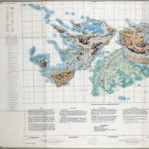
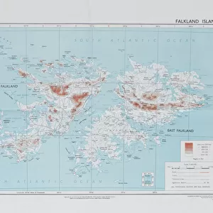
Directorate of Overseas Surveys map of the Falklands Islands, 1983 (c). One of four maps of the Falkland Islands, 1982 (c)-1984 (c). Associated with the South Atlantic (Falklands War), (1982) Date: circa 1860
Mary Evans Picture Library makes available wonderful images created for people to enjoy over the centuries
Media ID 14403821
© The National Army Museum / Mary Evans Picture Library
1982 1983 1984 Associated Atlantic Falkland Falklands Maps Overseas Surveying Surveys Directorate
15"x10" (38x25cm) Metal Print
Experience the historical significance of the Falklands War with our stunning Metal Prints from Media Storehouse. This captivating image, sourced from Mary Evans Prints Online, features a Directorate of Overseas Surveys map of the Falklands Islands from 1983. A poignant reminder of the events of 1982, this high-quality Metal Print is not only a beautiful addition to your home or office décor, but also a testament to historical accuracy and preservation. With vibrant colors and exceptional detail, our Metal Prints are sure to impress and inspire.
Your image is printed photographically and bonded to a 3.5mm thick, Dibond board (black polyethylene sandwiched between two sheets of white coated aluminium). The panel is then sealed with a gloss protective covering. Supplied complete with a wall mount which holds the print 10mm from the wall.
Made with durable metal and luxurious printing techniques, metal prints bring images to life and add a modern touch to any space
Estimated Product Size is 38.1cm x 25.4cm (15" x 10")
These are individually made so all sizes are approximate
Artwork printed orientated as per the preview above, with landscape (horizontal) or portrait (vertical) orientation to match the source image.
FEATURES IN THESE COLLECTIONS
> Europe
> United Kingdom
> Scotland
> Fife
> Falkland
> Maps and Charts
> Related Images
> South America
> Falkland Islands
> Maps
> South America
> Falkland Islands
> Related Images
EDITORS COMMENTS
This historic map print depicts the Falkland Islands, created by the Directorate of Overseas Surveys in 1983, following the South Atlantic (Falklands) War in 1982. The conflict between Argentina and the United Kingdom over the sovereignty of the islands resulted in a brief but intense military engagement. Prior to the war, the cartographic knowledge of the Falklands was based on outdated maps from the late 19th century. In response to the conflict, the British government commissioned the Directorate of Overseas Surveys to produce updated and accurate maps of the islands. This map, one of four produced between 1982 and 1984, provides a detailed and precise representation of the Falklands' geography. The map's title, "Falkland Islands, 1983," is inscribed in the lower left corner, with the scale and orientation indicated in the lower right. The map's historical significance lies in its role as a product of the South Atlantic (Falklands) War, a pivotal moment in the history of the Falkland Islands and the relationship between Argentina and the United Kingdom. The map serves as a testament to the importance of accurate cartographic information in times of conflict, as well as the role of surveying and mapping in shaping our understanding of the world.
MADE IN THE UK
Safe Shipping with 30 Day Money Back Guarantee
FREE PERSONALISATION*
We are proud to offer a range of customisation features including Personalised Captions, Color Filters and Picture Zoom Tools
SECURE PAYMENTS
We happily accept a wide range of payment options so you can pay for the things you need in the way that is most convenient for you
* Options may vary by product and licensing agreement. Zoomed Pictures can be adjusted in the Basket.