Photographic Print > Europe > United Kingdom > England > London > Sights > British Museum
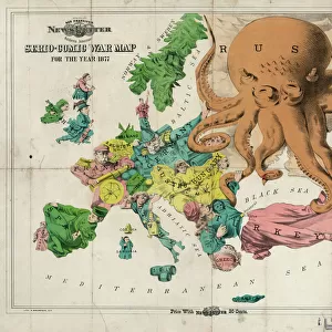
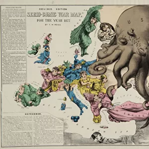
Photographic Print : Serio-Comic War Map For The Year 1877, 1877


![]()
Photo Prints from Heritage Images
Serio-Comic War Map For The Year 1877, 1877
Serio-Comic War Map For The Year 1877, 1877. Found in the collection of State History Museum, Moscow
Heritage Images features heritage image collections
Media ID 15043436
© Fine Art Images
1877 1878 Balkan Balkan War Balkans Geopolitics Great Britain Ottoman Empire Ottomans Pan Slavism Panslavism Propaganda Russian Army Russian Troops Russo Turkish War Russo Turkish War 1877 1878 Colour Lithograph
10"x8" (25x20cm) Photo Print
Introducing the captivating "Serio-Comic War Map for the Year 1877, 1877" from Media Storehouse's exclusive Heritage Images collection. This intriguing historical artifact, held in the esteemed State History Museum in Moscow, offers a unique and humorous perspective on the military conflicts of 1877. The map masterfully combines serious military details with comical illustrations, creating an engaging and educational piece for history enthusiasts and art collectors alike. Bring a touch of whimsy and historical depth to your home or office with this one-of-a-kind, museum-quality print.
Printed on archival quality paper for unrivalled stable artwork permanence and brilliant colour reproduction with accurate colour rendition and smooth tones. Printed on professional 234gsm Fujifilm Crystal Archive DP II paper. 10x8 for landscape images, 8x10 for portrait images.
Our Photo Prints are in a large range of sizes and are printed on Archival Quality Paper for excellent colour reproduction and longevity. They are ideal for framing (our Framed Prints use these) at a reasonable cost. Alternatives include cheaper Poster Prints and higher quality Fine Art Paper, the choice of which is largely dependant on your budget.
Estimated Image Size (if not cropped) is 25.4cm x 18.6cm (10" x 7.3")
Estimated Product Size is 25.4cm x 20.3cm (10" x 8")
These are individually made so all sizes are approximate
Artwork printed orientated as per the preview above, with landscape (horizontal) orientation to match the source image.
FEATURES IN THESE COLLECTIONS
> Arts
> Pop art
> Satire
> Satirical artwork
> Asia
> Turkey
> Related Images
> Europe
> Related Images
> Europe
> Russia
> Related Images
> Europe
> United Kingdom
> England
> London
> Sights
> British Museum
> Maps and Charts
> British Empire Maps
> Maps and Charts
> Related Images
EDITORS COMMENTS
This print showcases the "Serio-Comic War Map For The Year 1877" created in 1877. Housed in the esteemed State History Museum in Moscow, this fine piece of graphic art offers a fascinating glimpse into history and geopolitics. The map, a vibrant colour lithograph, humorously depicts the Russo-Turkish War of 1877-1878 with great attention to detail. It cleverly satirizes various European powers involved in the conflict, including Great Britain and the Ottoman Empire. Panslavism and Pan-Slavic sentiments are also prominently featured. Created by Frederick William Rose (1849-1915), this work is an excellent example of European satirical maps from that era. Its purpose was undoubtedly to serve as propaganda during a time when tensions were high between Russia and Turkey. Through its intricate illustrations, it provides valuable insight into the military strategies employed by both Russian troops and their adversaries during this significant historical event. As a curiosity map, it not only captures one's attention but also invites viewers to delve deeper into understanding the complex dynamics at play during this period. This print serves as a testament to how art can be used as a powerful tool for political commentary and historical documentation.
MADE IN THE UK
Safe Shipping with 30 Day Money Back Guarantee
FREE PERSONALISATION*
We are proud to offer a range of customisation features including Personalised Captions, Color Filters and Picture Zoom Tools
SECURE PAYMENTS
We happily accept a wide range of payment options so you can pay for the things you need in the way that is most convenient for you
* Options may vary by product and licensing agreement. Zoomed Pictures can be adjusted in the Basket.