Photographic Print > Fine Art Storehouse > Map > Reference Maps
Photographic Print : United States reference map


Resolution may be reduced at this size (83 DPI)
![]()
Photo Prints From Fine Art Storehouse
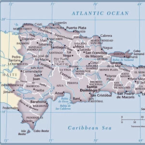
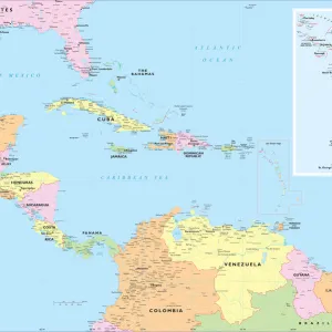
United States reference map
Fine Art Storehouse Maps: Reference Maps
Unleash your creativity and transform your space into a visual masterpiece!
Media ID 14431161
10"x8" (25x20cm) Photo Print
Discover the beauty of the United States with our exquisite Fine Art Storehouse Reference Maps. Our high-quality photographic prints of this intricately detailed United States map are not just functional tools, but also stunning works of art. Each print is meticulously crafted to showcase the vibrant colors and intricate lines of the map, making it a perfect addition to your home or office decor. Bring history and geography to life with this beautiful and functional piece from the Media Storehouse range of Fine Art Maps.
Printed on archival quality paper for unrivalled stable artwork permanence and brilliant colour reproduction with accurate colour rendition and smooth tones. Printed on professional 234gsm Fujifilm Crystal Archive DP II paper. 10x8 for landscape images, 8x10 for portrait images.
Our Photo Prints are in a large range of sizes and are printed on Archival Quality Paper for excellent colour reproduction and longevity. They are ideal for framing (our Framed Prints use these) at a reasonable cost. Alternatives include cheaper Poster Prints and higher quality Fine Art Paper, the choice of which is largely dependant on your budget.
Estimated Product Size is 20.3cm x 25.4cm (8" x 10")
These are individually made so all sizes are approximate
Artwork printed orientated as per the preview above, with portrait (vertical) orientation to match the source image.
EDITORS COMMENTS
This print showcases a meticulously detailed United States reference map, brought to you by Fine Art Storehouse Maps: Reference Maps. With its intricate cartography and rich colors, this artwork is a testament to the beauty and complexity of our great nation. Every state is clearly delineated, allowing viewers to explore the vast diversity that makes up the United States. From the rugged mountains of the West Coast to the sprawling plains of the Midwest, this map captures it all with stunning accuracy. The rivers, lakes, and coastlines are intricately depicted, highlighting their importance in shaping both geography and history. The attention to detail in this print is truly remarkable; even small towns and major cities are labeled for easy navigation. Whether you're planning a road trip or simply curious about different regions within America's borders, this reference map provides an invaluable resource for exploration. Perfectly suited for any home or office space, this art piece adds sophistication and educational value to any setting. Its timeless appeal transcends generations as it invites viewers on a visual journey across one of Earth's most diverse countries.
MADE IN THE UK
Safe Shipping with 30 Day Money Back Guarantee
FREE PERSONALISATION*
We are proud to offer a range of customisation features including Personalised Captions, Color Filters and Picture Zoom Tools
SECURE PAYMENTS
We happily accept a wide range of payment options so you can pay for the things you need in the way that is most convenient for you
* Options may vary by product and licensing agreement. Zoomed Pictures can be adjusted in the Basket.