Photographic Print > Europe > Portugal > Maps
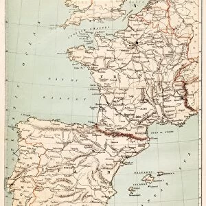
Photographic Print : Spain and Portugal map 1875


![]()
Photo Prints from Fine Art Storehouse
Spain and Portugal map 1875
Illustration of a Spain and Portugal map 1875
Unleash your creativity and transform your space into a visual masterpiece!
Nastasic
Media ID 15309460
© This content is subject to copyright
10"x8" (25x20cm) Photo Print
Step back in time with our exquisite 'Spain and Portugal Map 1875' print from Nastasic's Fine Art Storehouse collection. This stunning vintage map transports you to an era of exploration and discovery. The intricate detailing of borders, territories, and geographical features is a testament to the cartographic artistry of the past. Add this captivating piece to your home or office to ignite conversations and inspire wanderlust. Experience history in a whole new way with our high-quality, museum-grade photographic prints.
Printed on archival quality paper for unrivalled stable artwork permanence and brilliant colour reproduction with accurate colour rendition and smooth tones. Printed on professional 234gsm Fujifilm Crystal Archive DP II paper. 10x8 for landscape images, 8x10 for portrait images.
Our Photo Prints are in a large range of sizes and are printed on Archival Quality Paper for excellent colour reproduction and longevity. They are ideal for framing (our Framed Prints use these) at a reasonable cost. Alternatives include cheaper Poster Prints and higher quality Fine Art Paper, the choice of which is largely dependant on your budget.
Estimated Product Size is 25.4cm x 20.3cm (10" x 8")
These are individually made so all sizes are approximate
Artwork printed orientated as per the preview above, with landscape (horizontal) or portrait (vertical) orientation to match the source image.
FEATURES IN THESE COLLECTIONS
> Fine Art Storehouse
> Map
> Historical Maps
> Europe
> Portugal
> Related Images
> Europe
> Spain
> Related Images
> Maps and Charts
> Related Images
> Maps and Charts
> Spain
EDITORS COMMENTS
This print showcases a remarkable piece of history - an illustration of the Spain and Portugal map from 1875. With intricate details and exquisite craftsmanship, this artwork takes us on a journey back in time to explore the geographical landscape of these two Iberian Peninsula countries. The map, skillfully created by Nastasic, offers a glimpse into the political boundaries, cities, rivers, and mountain ranges that defined Spain and Portugal during this era. It serves as a testament to the cartographic expertise prevalent in the late 19th century. As we gaze upon this vintage masterpiece, we are transported to a time when exploration was at its peak and discoveries were being made across continents. The delicate lines etched onto paper evoke a sense of wonderment about what lies beyond those borders - uncharted territories waiting to be explored. The sepia tones used in this print add an air of nostalgia, reminding us of an era long gone but not forgotten. This artwork is not just about geography; it represents cultural heritage and historical significance that shaped these nations' identities. Whether you are an avid collector or simply appreciate art's ability to capture moments frozen in time, this Spain and Portugal map print will undoubtedly become a cherished addition to any space. Its timeless beauty invites us to reflect on our past while embracing the possibilities that lie ahead.
MADE IN THE UK
Safe Shipping with 30 Day Money Back Guarantee
FREE PERSONALISATION*
We are proud to offer a range of customisation features including Personalised Captions, Color Filters and Picture Zoom Tools
SECURE PAYMENTS
We happily accept a wide range of payment options so you can pay for the things you need in the way that is most convenient for you
* Options may vary by product and licensing agreement. Zoomed Pictures can be adjusted in the Basket.