Photographic Print > North America > Nicaragua > Maps
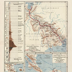
Photographic Print : Map of projects of Panama and Nicaragua Canal, lithograph, 1897


![]()
Photo Prints From Fine Art Storehouse
Map of projects of Panama and Nicaragua Canal, lithograph, 1897
Map of the historical projects of the Panama Canal (unfinished construction) and the Nicaragua Canal (in planning). Lithograph, published in 1897
Unleash your creativity and transform your space into a visual masterpiece!
ZU_09
Media ID 35843052
12"x8" (30x20cm) Photo Print
Step back in time with our exquisite antique print from Media Storehouse's Fine Art Collection. This captivating lithograph, created in 1897, showcases the historical plans for the Panama Canal and the proposed Nicaragua Canal. With intricate detail and stunning accuracy, ZU_09's Map of Projects of Panama and Nicaragua Canal transports you to an era of ambitious engineering projects and geographical exploration. Add this unique piece to your home or office decor and bring a piece of history into your space.
Printed on archival quality paper for unrivalled stable artwork permanence and brilliant colour reproduction with accurate colour rendition and smooth tones. Printed on professional 234gsm Fujifilm Crystal Archive DP II paper. 12x8 for landscape images, 8x12 for portrait images.
Our Photo Prints are in a large range of sizes and are printed on Archival Quality Paper for excellent colour reproduction and longevity. They are ideal for framing (our Framed Prints use these) at a reasonable cost. Alternatives include cheaper Poster Prints and higher quality Fine Art Paper, the choice of which is largely dependant on your budget.
Estimated Product Size is 30.5cm x 20.3cm (12" x 8")
These are individually made so all sizes are approximate
Artwork printed orientated as per the preview above, with landscape (horizontal) orientation to match the source image.
FEATURES IN THESE COLLECTIONS
> Maps and Charts
> Early Maps
> Maps and Charts
> Related Images
> North America
> Nicaragua
> Maps
> North America
> Nicaragua
> Related Images
> North America
> Panama
> Maps
> North America
> Panama
> Related Images
EDITORS COMMENTS
This striking lithograph from 1897 showcases the ambitious plans for two major canal projects in Central America - the Panama Canal and the Nicaragua Canal. The detailed map provides a fascinating glimpse into the historical efforts to connect the Atlantic and Pacific Oceans, highlighting both completed sections of the Panama Canal and proposed routes for the Nicaragua Canal.
The intricate design of this print captures the intricate network of waterways, locks, and construction sites that were integral to these monumental engineering feats. It serves as a visual reminder of the determination and ingenuity required to overcome geographical obstacles and create vital trade routes between continents.
As we reflect on this historic map, we are reminded of the visionaries who dared to dream big and transform these ideas into reality. The Panama Canal stands as a testament to human perseverance and innovation, while the plans for a potential Nicaragua Canal offer insight into ongoing efforts to improve global connectivity.
Whether you're a history buff, an admirer of cartography, or simply intrigued by tales of exploration and discovery, this lithograph is sure to captivate your imagination. Display it proudly in your home or office as a conversation piece that sparks curiosity about past endeavors and future possibilities.
MADE IN THE UK
Safe Shipping with 30 Day Money Back Guarantee
FREE PERSONALISATION*
We are proud to offer a range of customisation features including Personalised Captions, Color Filters and Picture Zoom Tools
SECURE PAYMENTS
We happily accept a wide range of payment options so you can pay for the things you need in the way that is most convenient for you
* Options may vary by product and licensing agreement. Zoomed Pictures can be adjusted in the Basket.