Photographic Print > Arts > Artists > O > Oceanic Oceanic
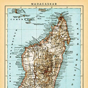
Photographic Print : Map of East Africa and Madagascar, 1596 (hand coloured engraving)
")

![]()
Photo Prints from Fine Art Finder
Map of East Africa and Madagascar, 1596 (hand coloured engraving)
STC239178 Map of East Africa and Madagascar, 1596 (hand coloured engraving) by Langren, Arnold Florent van (1571-1644); 39x56 cm; Private Collection; (add.info.: companion map to Itinerario by Jan Huygen van Linschoten (1563-1611) who documented his travels to the Indies in service of Archbishop of Goa; ); The Stapleton Collection; Dutch, out of copyright
Media ID 22941992
© The Stapleton Collection / Bridgeman Images
Indian Ocean Mozambique Sailing Ships Sea Chart
10"x8" (25x20cm) Photo Print
Discover the rich history of East Africa and Madagascar with this stunning, hand-colored engraving from Bridgeman Images. Dating back to 1596, this rare map by Arnold Florent van Langren offers a fascinating glimpse into the cartographic knowledge of the time. The intricate details and vibrant colors bring the lands and waters of this region to life, making it a must-have for history buffs, cartographers, and art enthusiasts alike. Add this beautiful piece to your collection from Fine Art Finder and transport yourself back in time.
Printed on archival quality paper for unrivalled stable artwork permanence and brilliant colour reproduction with accurate colour rendition and smooth tones. Printed on professional 234gsm Fujifilm Crystal Archive DP II paper. 10x8 for landscape images, 8x10 for portrait images.
Our Photo Prints are in a large range of sizes and are printed on Archival Quality Paper for excellent colour reproduction and longevity. They are ideal for framing (our Framed Prints use these) at a reasonable cost. Alternatives include cheaper Poster Prints and higher quality Fine Art Paper, the choice of which is largely dependant on your budget.
Estimated Image Size (if not cropped) is 25.4cm x 17.8cm (10" x 7")
Estimated Product Size is 25.4cm x 20.3cm (10" x 8")
These are individually made so all sizes are approximate
Artwork printed orientated as per the preview above, with landscape (horizontal) orientation to match the source image.
FEATURES IN THESE COLLECTIONS
> Fine Art Finder
> Artists
> Arnold Florent van Langren
> Fine Art Finder
> Artists
> Joseph Nollekens
> Fine Art Finder
> Maps (celestial & Terrestrial)
> Africa
> Madagascar
> Maps
> Africa
> Madagascar
> Related Images
> Africa
> Mozambique
> Maps
> Africa
> Mozambique
> Related Images
> Arts
> Artists
> O
> Oceanic Oceanic
EDITORS COMMENTS
This hand-coloured engraving, titled "Map of East Africa and Madagascar, 1596" takes us on a journey back in time to the Age of Exploration. Created by Arnold Florent van Langren, a Dutch cartographer from the 16th century, this map measures an impressive 39x56 cm and is part of a private collection. The intricate details showcased in this print are truly remarkable. It depicts the coastline of East Africa and Madagascar with precision, offering sailors and explorers valuable information for their voyages across the Indian Ocean. The presence of sailing ships scattered throughout the sea chart adds an air of adventure to this historical piece. Notably, this map serves as a companion to Jan Huygen van Linschoten's renowned travelogue called "Itinerario". Linschoten documented his travels to the Indies while serving under the Archbishop of Goa. This collaboration between two influential figures provides invaluable insights into maritime exploration during that era. As we gaze upon this engraving, we can almost feel ourselves being transported back in time - imagining brave sailors navigating treacherous waters along Mozambique's shoreline or discovering uncharted territories on remote islands. Its artistic quality combined with its historical significance makes it a true gem within The Stapleton Collection. With its rich hues and meticulous attention to detail, this print captures both our imagination and curiosity about past expeditions that shaped our understanding of these regions. A testament to human ingenuity and exploration, it reminds us how far we
MADE IN THE UK
Safe Shipping with 30 Day Money Back Guarantee
FREE PERSONALISATION*
We are proud to offer a range of customisation features including Personalised Captions, Color Filters and Picture Zoom Tools
SECURE PAYMENTS
We happily accept a wide range of payment options so you can pay for the things you need in the way that is most convenient for you
* Options may vary by product and licensing agreement. Zoomed Pictures can be adjusted in the Basket.