Photo Mug > Animals > Fishes > G > Grouper
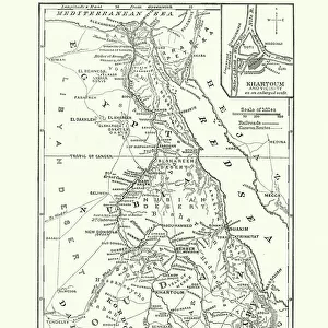
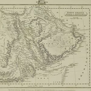
Photo Mug : Map Of Egypt, Sudan, 1899


![]()
Home Decor from Universal Images Group (UIG)
Map Of Egypt, Sudan, 1899
Universal Images Group (UIG) manages distribution for many leading specialist agencies worldwide
Media ID 20165149
© Universal Images Group
1872 Engraving 1899 Egypt Heir Nineteenth Century Map Sudan Wandering
Photo Mug
Add a touch of history to your daily routine with our Media Storehouse Photo Mug featuring the classic Map of Egypt and Sudan, dated 1899 from the Universal History Archive by Universal Images Group (UIG). This high-quality mug showcases intricate details of the map, transporting you back in time with every sip. Perfect for history enthusiasts, travelers, or anyone who appreciates the beauty of vintage maps, this mug is not only functional but also a unique conversation starter. Embrace the past, one mug at a time.
A personalised photo mug blends sentimentality with functionality, making an ideal gift for cherished loved ones, close friends, or valued colleagues. Preview may show both sides of the same mug.
Elevate your coffee or tea experience with our premium white ceramic mug. Its wide, comfortable handle makes drinking easy, and you can rely on it to be both microwave and dishwasher safe. Sold in single units, preview may show both sides of the same mug so you can see how the picture wraps around.
Mug Size is 9.5cm high x 8cm diameter (3.7" x 3.1")
These are individually made so all sizes are approximate
FEATURES IN THESE COLLECTIONS
> Africa
> Egypt
> Related Images
> Africa
> Sudan
> Related Images
> Animals
> Fishes
> G
> Grouper
> Maps and Charts
> Related Images
> Universal Images Group (UIG)
> History
> Historical Maps
EDITORS COMMENTS
This print showcases a remarkable piece of history, the "Map Of Egypt, Sudan, 1899". Transporting us back to the late nineteenth century, this intricately detailed map offers a glimpse into the past and invites us to explore the rich cultural heritage of Egypt and Sudan. The vintage charm exuded by this 1872 engraving is truly enchanting. Its retro-styled design takes us on a visual journey through time, evoking memories of Victorian-era exploration and discovery. The illustrative technique employed in this heirloom artwork demonstrates the immense skill and craftsmanship prevalent during that era. As we delve deeper into this historic art piece, we are reminded of the importance of maps as tools for understanding our world. This particular map serves as an invaluable resource for historians and enthusiasts alike who seek to unravel the complexities of Egypt's relationship with its neighboring country Sudan during that period. The Map Of Egypt, Sudan, 1899 not only captures our attention but also sparks curiosity about ancient civilizations and their interconnectedness. It stands as a testament to mankind's enduring fascination with wanderlust and exploration. Thanks to Universal Images Group (UIG), we can now appreciate this engraved image in all its glory. Their dedication to preserving historical artifacts allows us to relish in these timeless treasures from afar while celebrating arts and culture from around the globe.
MADE IN THE UK
Safe Shipping with 30 Day Money Back Guarantee
FREE PERSONALISATION*
We are proud to offer a range of customisation features including Personalised Captions, Color Filters and Picture Zoom Tools
SECURE PAYMENTS
We happily accept a wide range of payment options so you can pay for the things you need in the way that is most convenient for you
* Options may vary by product and licensing agreement. Zoomed Pictures can be adjusted in the Basket.