Photo Mug > Asia > Turkey > Istanbul
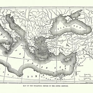
Photo Mug : Turkey / Istanbul / Map 1835


![]()
Home Decor from Mary Evans Picture Library
Turkey / Istanbul / Map 1835
Map of Istanbul (Constantinople). Date: circa 1835
Mary Evans Picture Library makes available wonderful images created for people to enjoy over the centuries
Media ID 14271953
© Mary Evans Picture Library
Photo Mug
Add a touch of history to your daily routine with our Media Storehouse Photo Mugs. Featuring the captivating "Turkey / Istanbul / Map 1835" image from Mary Evans Prints Online, these mugs bring the rich history of Istanbul (Constantinople) right to your kitchen table. The high-quality print on our durable ceramic mugs ensures that the intricate details of the 1835 map remain vibrant and clear, making each sip an adventure. Perfect for history enthusiasts, travelers, or anyone who appreciates the beauty of the past, our Photo Mugs make for unique and thoughtful gifts. Embrace the storytelling power of a picture with every use.
A personalised photo mug blends sentimentality with functionality, making an ideal gift for cherished loved ones, close friends, or valued colleagues. Preview may show both sides of the same mug.
Elevate your coffee or tea experience with our premium white ceramic mug. Its wide, comfortable handle makes drinking easy, and you can rely on it to be both microwave and dishwasher safe. Sold in single units, preview may show both sides of the same mug so you can see how the picture wraps around.
Mug Size is 8cm high x 9.5cm diameter (3.1" x 3.7")
These are individually made so all sizes are approximate
FEATURES IN THESE COLLECTIONS
> Asia
> Turkey
> Related Images
> Maps and Charts
> Related Images
EDITORS COMMENTS
This map print, dating back to circa 1835, offers a fascinating glimpse into the historical layout of Istanbul, then known as Constantinople, during the Ottoman Empire. The map, titled "Plan of Constantinople," was created approximately 150 years before the city would undergo significant modernization. Istanbul, a city rich in history and cultural diversity, is depicted in this map with intricate detail. The Bosphorus Strait, the natural waterway that divides Europe and Asia, is clearly marked, as are the city's major landmarks such as the Hagia Sophia, the Blue Mosque, and the Topkapi Palace. The map also highlights the city's fortifications, including the famous Walls of Constantinople, which protected the city from external threats for centuries. The map's intricate detail not only showcases the architectural and geographical features of Istanbul but also provides insight into the city's urban planning during the Ottoman era. The various districts, including the European and Asian sides, are clearly labeled, and the streets are neatly laid out, reflecting the city's organized layout. The map's antique charm transports us back in time, allowing us to visualize Istanbul as it was over 180 years ago. It serves as a reminder of the city's rich history and its role as a cultural melting pot, long before the modern world began to encroach upon its ancient walls. This map print is an essential addition to any collection of historical maps or for those with a passion for Istanbul's fascinating history.
MADE IN THE UK
Safe Shipping with 30 Day Money Back Guarantee
FREE PERSONALISATION*
We are proud to offer a range of customisation features including Personalised Captions, Color Filters and Picture Zoom Tools
FREE COLORIZATION SERVICE
You can choose advanced AI Colorization for this picture at no extra charge!
SECURE PAYMENTS
We happily accept a wide range of payment options so you can pay for the things you need in the way that is most convenient for you
* Options may vary by product and licensing agreement. Zoomed Pictures can be adjusted in the Basket.