Metal Print > Asia > Turkey > Istanbul
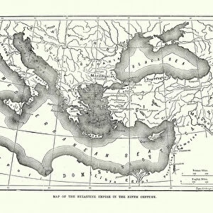
Metal Print : Turkey / Istanbul / Map 1835


![]()
Metal Prints from Mary Evans Picture Library
Turkey / Istanbul / Map 1835
Map of Istanbul (Constantinople). Date: circa 1835
Mary Evans Picture Library makes available wonderful images created for people to enjoy over the centuries
Media ID 14271953
© Mary Evans Picture Library
15"x10" (38x25cm) Metal Print
Discover the rich history of Istanbul (formerly known as Constantinople) with our stunning Metal Prints from Media Storehouse. Featuring an intricately detailed map of the city from circa 1835, sourced from the extensive collection at Mary Evans Prints Online, these high-quality prints are sure to be a conversation starter in any home or office. The vibrant colors and sharp details are brought to life through the unique process of printing on metal, creating a modern and sophisticated look that is both durable and eye-catching. Transport yourself back in time and add a touch of history to your space with our Istanbul Metal Print.
Your image is printed photographically and bonded to a 3.5mm thick, Dibond board (black polyethylene sandwiched between two sheets of white coated aluminium). The panel is then sealed with a gloss protective covering. Supplied complete with a wall mount which holds the print 10mm from the wall.
Made with durable metal and luxurious printing techniques, metal prints bring images to life and add a modern touch to any space
Estimated Product Size is 38.1cm x 25.4cm (15" x 10")
These are individually made so all sizes are approximate
Artwork printed orientated as per the preview above, with landscape (horizontal) or portrait (vertical) orientation to match the source image.
FEATURES IN THESE COLLECTIONS
> Asia
> Turkey
> Related Images
> Maps and Charts
> Related Images
EDITORS COMMENTS
This map print, dating back to circa 1835, offers a fascinating glimpse into the historical layout of Istanbul, then known as Constantinople, during the Ottoman Empire. The map, titled "Plan of Constantinople," was created approximately 150 years before the city would undergo significant modernization. Istanbul, a city rich in history and cultural diversity, is depicted in this map with intricate detail. The Bosphorus Strait, the natural waterway that divides Europe and Asia, is clearly marked, as are the city's major landmarks such as the Hagia Sophia, the Blue Mosque, and the Topkapi Palace. The map also highlights the city's fortifications, including the famous Walls of Constantinople, which protected the city from external threats for centuries. The map's intricate detail not only showcases the architectural and geographical features of Istanbul but also provides insight into the city's urban planning during the Ottoman era. The various districts, including the European and Asian sides, are clearly labeled, and the streets are neatly laid out, reflecting the city's organized layout. The map's antique charm transports us back in time, allowing us to visualize Istanbul as it was over 180 years ago. It serves as a reminder of the city's rich history and its role as a cultural melting pot, long before the modern world began to encroach upon its ancient walls. This map print is an essential addition to any collection of historical maps or for those with a passion for Istanbul's fascinating history.
MADE IN THE UK
Safe Shipping with 30 Day Money Back Guarantee
FREE PERSONALISATION*
We are proud to offer a range of customisation features including Personalised Captions, Color Filters and Picture Zoom Tools
FREE COLORIZATION SERVICE
You can choose advanced AI Colorization for this picture at no extra charge!
SECURE PAYMENTS
We happily accept a wide range of payment options so you can pay for the things you need in the way that is most convenient for you
* Options may vary by product and licensing agreement. Zoomed Pictures can be adjusted in the Basket.