Photo Mug > Europe > Italy > Sicily > Messina
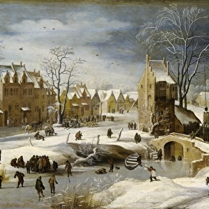
Photo Mug : Portolan Atlas, 1587. Map of the Iberian Peninsula


![]()
Home Decor from Mary Evans Picture Library
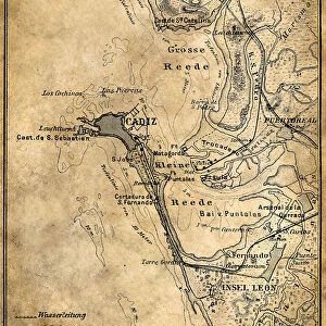
Portolan Atlas, 1587. Map of the Iberian Peninsula
Portolan Atlas, 1587. Map of the Iberian Peninsula, the north coastline of Africa and the Vasque Countrys region in France. Made in Messina. Facsimile. Miniature Painting. SPAIN. Madrid. National Library
Mary Evans Picture Library makes available wonderful images created for people to enjoy over the centuries
Media ID 8281785
© Mary Evans Picture Library 2015 - https://copyrighthub.org/s0/hub1/creation/maryevans/MaryEvansPictureID/10681999
Atlas Cartographic Coast Line Countrys Facsimile Iberian Illuminated Manuscript Manuscripts Messina Miniatures Peninsula Portolan Region Made
Photo Mug
Introducing our exclusive Media Storehouse Photo Mug, featuring the captivating Portolan Atlas, 1587. Map of the Iberian Peninsula. This beautiful design showcases an intricately detailed antique map, showcasing the north coastline of Africa and the Vasque Country region in France. Originally made in Messina and now available as a facsimile, this miniature painting from Madrid is a testament to the rich cartographic history of Spain. Bring a piece of the past to your daily routine with our high-quality, full-color photo mug that holds your favorite beverage in style.
A personalised photo mug blends sentimentality with functionality, making an ideal gift for cherished loved ones, close friends, or valued colleagues. Preview may show both sides of the same mug.
Elevate your coffee or tea experience with our premium white ceramic mug. Its wide, comfortable handle makes drinking easy, and you can rely on it to be both microwave and dishwasher safe. Sold in single units, preview may show both sides of the same mug so you can see how the picture wraps around.
Mug Size is 8cm high x 9.5cm diameter (3.1" x 3.7")
These are individually made so all sizes are approximate
FEATURES IN THESE COLLECTIONS
> Africa
> Related Images
> Europe
> Italy
> Sicily
> Messina
> Europe
> Spain
> Related Images
EDITORS COMMENTS
1. Title: A Glimpse into the Past: The Portolan Atlas of 1587 - A Masterpiece of Cartographic Art This image showcases a fascinating piece of cartographic history: the Portolan Atlas of 1587, a meticulously crafted map of the Iberian Peninsula, the north coastline of Africa, and the Vasque Country region in France. The map, housed in the National Library of Spain in Madrid, is a testament to the artistic and cartographic achievements of the late 16th century. Created in Messina, this intricately detailed map is a prime example of a portolan chart, a type of European map that originated in the 13th century. The map's title, "Portolan Atlas," refers to the Italian mariners who developed this cartographic tradition, using rhumb lines to represent the constant courses sailors would follow to navigate the Mediterranean Sea. The map's vibrant colors and intricate details are a result of its miniature painting and manuscript origins. Each coastal city, island, and landmass is meticulously depicted, with an emphasis on accuracy and geographical detail. The map's depiction of the Iberian Peninsula reveals the political divisions of the time, with the kingdoms of Castile, Aragon, and Navarre clearly distinguishable. The north coastline of Africa is also represented, with the Strait of Gibraltar connecting the Mediterranean Sea to the Atlantic Ocean. The Vasque Country region in France is also shown, highlighting the connections between the Iberian Peninsula and Europe during this period. This Portolan Atlas is a facsimile, a reproduction of the original map, allowing modern viewers to appreciate the beauty and historical significance of this remarkable cartographic masterpiece. The map's intricate details and artistic merit serve as a reminder of the rich cartographic heritage that continues to inspire and inform our understanding of the world today.
MADE IN THE UK
Safe Shipping with 30 Day Money Back Guarantee
FREE PERSONALISATION*
We are proud to offer a range of customisation features including Personalised Captions, Color Filters and Picture Zoom Tools
SECURE PAYMENTS
We happily accept a wide range of payment options so you can pay for the things you need in the way that is most convenient for you
* Options may vary by product and licensing agreement. Zoomed Pictures can be adjusted in the Basket.