Photo Mug > Europe > United Kingdom > England > London > Transport > Railway
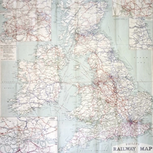
Photo Mug : Railway Map of England


![]()
Home Decor from Mary Evans Picture Library
Railway Map of England
London & North Western Railway Co rail map of England, 1899 Date: 1899
Mary Evans Picture Library makes available wonderful images created for people to enjoy over the centuries
Media ID 7402325
© Mary Evans Picture Library 2015 - https://copyrighthub.org/s0/hub1/creation/maryevans/MaryEvansPictureID/10473989
Photo Mug
"Bring the rich history of railway travel to your morning routine with our Media Storehouse Photo Mugs. Featuring an exquisite vintage image of a 1899 London & North Western Railway Co rail map of England from Mary Evans Prints Online, each mug is a perfect blend of functionality and style. Immerse yourself in the intricate details of this beautifully preserved railway map as you enjoy your favorite beverage. A thoughtful and unique gift for railway enthusiasts or anyone who appreciates the charm of nostalgia. Order yours today and start your day with a journey through time."
A personalised photo mug blends sentimentality with functionality, making an ideal gift for cherished loved ones, close friends, or valued colleagues. Preview may show both sides of the same mug.
Elevate your coffee or tea experience with our premium white ceramic mug. Its wide, comfortable handle makes drinking easy, and you can rely on it to be both microwave and dishwasher safe. Sold in single units, preview may show both sides of the same mug so you can see how the picture wraps around.
Mug Size is 9.5cm high x 8cm diameter (3.7" x 3.1")
These are individually made so all sizes are approximate
FEATURES IN THESE COLLECTIONS
> Mary Evans Prints Online
> National Archives
> Animals
> Mammals
> Muridae
> Western Mouse
> Europe
> United Kingdom
> England
> London
> Related Images
> Europe
> United Kingdom
> England
> London
> Transport
> Railway
> Europe
> United Kingdom
> England
> Maps
> Europe
> United Kingdom
> England
> Posters
> Europe
> United Kingdom
> England
> Railways
> Europe
> United Kingdom
> England
> Related Images
> Maps and Charts
> Related Images
> Popular Themes
> Railway Posters
EDITORS COMMENTS
This stunning vintage print showcases the intricate Railway Map of England from 1899, specifically highlighting the London & North Western Railway Co rail network. The detailed map provides a fascinating glimpse into the extensive train routes that crisscrossed through England during the 19th century.
The advertisement for this railway company is a true testament to the advancements in transportation and infrastructure during this time period. The carefully drawn lines and labels on the map illustrate just how interconnected England was by rail, allowing for easier travel and trade across the country.
As you study this piece of history, you can't help but marvel at the sheer scale of the English railway system in 1899. It's a reminder of how far we've come in terms of modern transportation and communication networks.
Whether you're a history buff, a train enthusiast, or simply appreciate beautiful vintage prints, this Railway Map of England is sure to captivate your imagination. Let yourself be transported back in time to an era when steam trains ruled the tracks and explore all that this incredible map has to offer.
MADE IN THE UK
Safe Shipping with 30 Day Money Back Guarantee
FREE PERSONALISATION*
We are proud to offer a range of customisation features including Personalised Captions, Color Filters and Picture Zoom Tools
SECURE PAYMENTS
We happily accept a wide range of payment options so you can pay for the things you need in the way that is most convenient for you
* Options may vary by product and licensing agreement. Zoomed Pictures can be adjusted in the Basket.