Antique Framed Print > Europe > United Kingdom > England > London > Transport > Railway
Antique Framed Print : Railway Map of England


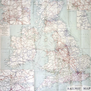
![]()
Framed Photos from Mary Evans Picture Library
Railway Map of England
London & North Western Railway Co rail map of England, 1899 Date: 1899
Mary Evans Picture Library makes available wonderful images created for people to enjoy over the centuries
Media ID 7402325
© Mary Evans Picture Library 2015 - https://copyrighthub.org/s0/hub1/creation/maryevans/MaryEvansPictureID/10473989
14"x12" (36x31cm) Antique Frame
Bevelled wood effect frame, card mounted, 10x8 archival quality photo print. Overall outside dimensions 14x12 inches (36x31cm). Environmentally and ozone friendly, the Polycore® moulding has the look of real wood, is durable and light and easy to hang. Biodegradable and made with non-chlorinated gases (no toxic fumes) it is efficient; producing 100 tons of polystyrene can save 300 tons of trees! Prints are glazed with lightweight, shatterproof, optical clarity acrylic (providing the same general protection from the environment as glass). The back is stapled hardboard with a sawtooth hanger attached. Note: To minimise original artwork cropping, for optimum layout, and to ensure print is secure, the visible print may be marginally smaller
Bevelled Wood Effect Framed and Mounted Prints - Professionally Made and Ready to Hang
Estimated Image Size (if not cropped) is 18.2cm x 24.4cm (7.2" x 9.6")
Estimated Product Size is 31.2cm x 36.3cm (12.3" x 14.3")
These are individually made so all sizes are approximate
Artwork printed orientated as per the preview above, with portrait (vertical) orientation to match the source image.
FEATURES IN THESE COLLECTIONS
> Animals
> Mammals
> Muridae
> Western Mouse
> Europe
> United Kingdom
> England
> London
> Related Images
> Europe
> United Kingdom
> England
> London
> Transport
> Railway
> Europe
> United Kingdom
> England
> Maps
> Europe
> United Kingdom
> England
> Posters
> Europe
> United Kingdom
> England
> Railways
> Europe
> United Kingdom
> England
> Related Images
> Maps and Charts
> Related Images
> Popular Themes
> Railway Posters
> Mary Evans Prints Online
> National Archives
EDITORS COMMENTS
This stunning vintage print showcases the intricate Railway Map of England from 1899, specifically highlighting the London & North Western Railway Co rail network. The detailed map provides a fascinating glimpse into the extensive train routes that crisscrossed through England during the 19th century.
The advertisement for this railway company is a true testament to the advancements in transportation and infrastructure during this time period. The carefully drawn lines and labels on the map illustrate just how interconnected England was by rail, allowing for easier travel and trade across the country.
As you study this piece of history, you can't help but marvel at the sheer scale of the English railway system in 1899. It's a reminder of how far we've come in terms of modern transportation and communication networks.
Whether you're a history buff, a train enthusiast, or simply appreciate beautiful vintage prints, this Railway Map of England is sure to captivate your imagination. Let yourself be transported back in time to an era when steam trains ruled the tracks and explore all that this incredible map has to offer.
MADE IN THE UK
Safe Shipping with 30 Day Money Back Guarantee
FREE PERSONALISATION*
We are proud to offer a range of customisation features including Personalised Captions, Color Filters and Picture Zoom Tools
SECURE PAYMENTS
We happily accept a wide range of payment options so you can pay for the things you need in the way that is most convenient for you
* Options may vary by product and licensing agreement. Zoomed Pictures can be adjusted in the Basket.