Photo Mug > Europe > Norway > Maps
Photo Mug : Map of Spitsbergen, Norway


![]()
Home Decor from Mary Evans Picture Library
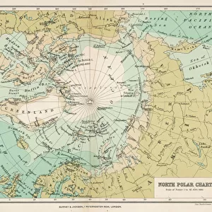
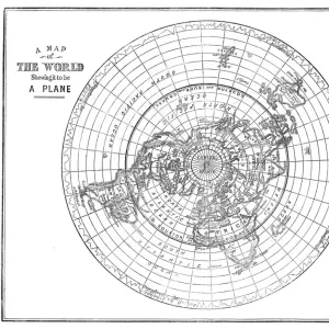
Map of Spitsbergen, Norway
Map of Spitsbergen, Svalbard, Norway Date: 1758
Mary Evans Picture Library makes available wonderful images created for people to enjoy over the centuries
Media ID 14267943
© Mary Evans Picture Library
1758 Maps Nordic Norway Norwegian Spitsbergen Spitzbergen Svalbard
Photo Mug
Introducing the Media Storehouse Photo Mugs, a unique and thoughtful gift that lets you carry your favorite memories with you everywhere. This exclusive range now features the stunning "Map of Spitsbergen, Norway" by Rights Managed from Mary Evans Prints Online. Dating back to 1758, this antique map showcases the captivating beauty of Svalbard, Norway, with intricate detail and historical charm. Each mug holds 11 oz. of your preferred beverage and is made of high-quality ceramic material, ensuring a sturdy and durable container. Perfect for coffee lovers, history enthusiasts, or anyone who appreciates the art of cartography, these Photo Mugs make a wonderful gift for any occasion. Embrace the power of personalization and let your favorite map transport you on every sip.
A personalised photo mug blends sentimentality with functionality, making an ideal gift for cherished loved ones, close friends, or valued colleagues. Preview may show both sides of the same mug.
Elevate your coffee or tea experience with our premium white ceramic mug. Its wide, comfortable handle makes drinking easy, and you can rely on it to be both microwave and dishwasher safe. Sold in single units, preview may show both sides of the same mug so you can see how the picture wraps around.
Mug Size is 8cm high x 9.5cm diameter (3.1" x 3.7")
These are individually made so all sizes are approximate
FEATURES IN THESE COLLECTIONS
> Europe
> Norway
> Related Images
> Europe
> Related Images
> Maps and Charts
> Related Images
EDITORS COMMENTS
1. Title: "Exploring the Frozen Frontier: A Glimpse into the 18th Century Cartography of Spitsbergen, Norway" This map print, dated 1758, offers a fascinating glimpse into the cartographic exploration of Spitsbergen, a remote archipelago located in the Arctic Ocean, north of mainland Norway and part of the Svalbard group of islands. The map, produced during the 18th century, is an essential piece of Nordic and Norwegian cartographic history. The intricate details on this map reveal the extensive knowledge that cartographers had acquired about the region up to that point in time. The map includes various islands, bays, and inlets, some of which may have been discovered only recently. The coastlines are delineated with remarkable precision, and the depth soundings provide valuable information for navigators. The map's title, "Carte des Costes Septentrionales de Norvege, ou Spitzberg," translates to "Map of the Northern Coasts of Norway, or Spitsbergen." The map's creator is not explicitly stated, but it is known that such maps were produced by various cartographers and publishers in Europe during the 18th century. The map's historical significance lies in its role as a crucial navigational tool for explorers and traders during the Age of Discovery. The map would have been essential for those venturing into the Arctic waters in search of valuable resources, such as whales, walruses, and furs. The map's accuracy and detail would have helped ensure the safety of these voyages and contributed to the expansion of European knowledge of the Arctic world. Today, this map serves as a testament to the intrepid spirit of exploration and the remarkable advancements in cartography during the 18th century. It is a reminder of the rich history and cultural significance of Spitsbergen and the Arctic region as a whole.
MADE IN THE UK
Safe Shipping with 30 Day Money Back Guarantee
FREE PERSONALISATION*
We are proud to offer a range of customisation features including Personalised Captions, Color Filters and Picture Zoom Tools
SECURE PAYMENTS
We happily accept a wide range of payment options so you can pay for the things you need in the way that is most convenient for you
* Options may vary by product and licensing agreement. Zoomed Pictures can be adjusted in the Basket.