Photo Mug > Europe > United Kingdom > Wales > Railways
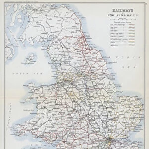
Photo Mug : Map / England & Wales 1857


![]()
Home Decor from Mary Evans Picture Library
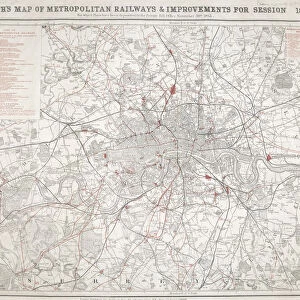
Map / England & Wales 1857
Map of England and Wales showing railways and canals
Mary Evans Picture Library makes available wonderful images created for people to enjoy over the centuries
Media ID 608789
© Mary Evans Picture Library 2015 - https://copyrighthub.org/s0/hub1/creation/maryevans/MaryEvansPictureID/10113950
Photo Mug
Introducing the Media Storehouse Photo Mug, a perfect blend of history and functionality. This mug features an exquisite image of "Map / England & Wales 1857" from Mary Evans Picture Library, showcasing the intricate details of the railways and canals that shaped the landscape of England and Wales during that era. Travel back in time with every sip from this beautifully designed mug. The high-quality print ensures vibrant colors and long-lasting durability. Make your morning coffee or afternoon tea more enjoyable with this unique and captivating addition to your collection.
A personalised photo mug blends sentimentality with functionality, making an ideal gift for cherished loved ones, close friends, or valued colleagues. Preview may show both sides of the same mug.
Elevate your coffee or tea experience with our premium white ceramic mug. Its wide, comfortable handle makes drinking easy, and you can rely on it to be both microwave and dishwasher safe. Sold in single units, preview may show both sides of the same mug so you can see how the picture wraps around.
Mug Size is 9.5cm high x 8cm diameter (3.7" x 3.1")
These are individually made so all sizes are approximate
FEATURES IN THESE COLLECTIONS
> Europe
> United Kingdom
> England
> Maps
> Europe
> United Kingdom
> England
> Posters
> Europe
> United Kingdom
> England
> Railways
> Europe
> United Kingdom
> England
> Related Images
> Europe
> United Kingdom
> Wales
> Maps
> Europe
> United Kingdom
> Wales
> Posters
> Europe
> United Kingdom
> Wales
> Railways
> Europe
> United Kingdom
> Wales
> Related Images
> Maps and Charts
> Early Maps
> Maps and Charts
> Related Images
EDITORS COMMENTS
This stunning print of a map from 1857 showcases the intricate railway and canal systems of England and Wales during that time period. The detailed cartography provides a fascinating glimpse into the historical transportation networks that connected major cities and regions across Britain.
The map is not only a valuable resource for historians, but also serves as a beautiful piece of art with its intricate lines and labels depicting various towns, rivers, and landmarks throughout England and Wales. It captures an era when railways were rapidly expanding across the country, revolutionizing travel and trade in ways never seen before.
As we study this map, we can imagine the hustle and bustle of steam trains chugging along tracks, carrying passengers and goods to their destinations. We can envision the vital role that canals played in transporting goods between different regions, linking industrial centers with ports for international trade.
This print is not just a geographical representation; it is a window into the past that allows us to appreciate how far transportation technology has come since 1857. It reminds us of the importance of infrastructure in shaping societies and economies, making it a timeless piece that continues to captivate viewers today.
MADE IN THE UK
Safe Shipping with 30 Day Money Back Guarantee
FREE PERSONALISATION*
We are proud to offer a range of customisation features including Personalised Captions, Color Filters and Picture Zoom Tools
SECURE PAYMENTS
We happily accept a wide range of payment options so you can pay for the things you need in the way that is most convenient for you
* Options may vary by product and licensing agreement. Zoomed Pictures can be adjusted in the Basket.