Photo Mug > Europe > United Kingdom > Scotland > Fife > Kincardine
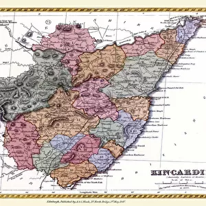
Photo Mug : Old Map of the County of Kincardine from the Philips Handy Atlas of 1882


![]()
Home Decor from MapSeeker
Old Map of the County of Kincardine from the Philips Handy Atlas of 1882
PHA018
Welcome to the Mapseeker Image library and enter an historic gateway to one of the largest on-line collections of Historic Maps, Nostalgic Views, Vista's and Panorama's from a World gone by.
Media ID 20348171
County Map County Map Of Scotland Historic Map Old County Map Old Scottish County Map Scottish County Map Kincardine Kincardineshire
Photo Mug
Bring a piece of history to your morning routine with the Media Storehouse Old Map Mug featuring an intricately detailed image of an Old Map of the County of Kincardine from the Philips Handy Atlas of 1882, sourced from MapSeeker. Each mug holds your favorite beverage in high style, making it a unique and thoughtful gift for history enthusiasts or anyone who appreciates the charm of vintage maps. Relive the past with every sip.
A personalised photo mug blends sentimentality with functionality, making an ideal gift for cherished loved ones, close friends, or valued colleagues. Preview may show both sides of the same mug.
Elevate your coffee or tea experience with our premium white ceramic mug. Its wide, comfortable handle makes drinking easy, and you can rely on it to be both microwave and dishwasher safe. Sold in single units, preview may show both sides of the same mug so you can see how the picture wraps around.
Mug Size is 9.5cm high x 8cm diameter (3.7" x 3.1")
These are individually made so all sizes are approximate
FEATURES IN THESE COLLECTIONS
> MapSeeker
> Maps from the British Isles
> Scotland and Counties PORTFOLIO
> Europe
> United Kingdom
> Scotland
> Fife
> Kincardine
> Europe
> United Kingdom
> Scotland
> Kincardineshire
> Europe
> United Kingdom
> Scotland
> Maps
> Europe
> United Kingdom
> Scotland
> Posters
> Europe
> United Kingdom
> Scotland
> Related Images
> Maps and Charts
> Early Maps
> Maps and Charts
> Related Images
EDITORS COMMENTS
This print showcases an exquisite piece of history - the Old Map of the County of Kincardine from the Philips Handy Atlas of 1882 (PHA018). With its intricate details and vintage charm, this Scottish county map takes us on a journey back in time. Steeped in rich heritage, this old county map offers a glimpse into the past, allowing us to explore Kincardine's fascinating landscape and historical landmarks. From its rolling hills to winding rivers, every contour is meticulously depicted, offering a sense of authenticity that transports us to another era. As we delve deeper into this historic map, we uncover the enchanting tales embedded within each corner. The boundaries of Kincardineshire come alive as we trace our fingers along ancient roads and discover long-forgotten villages nestled amidst picturesque countryside. This remarkable print not only serves as a visual delight but also acts as a valuable educational resource for historians and enthusiasts alike. It provides invaluable insights into Scotland's cultural heritage while preserving the legacy of Kincardine for generations to come. Whether you are an avid collector or simply appreciate the beauty found in antiquity, this old county map is sure to captivate your imagination. Display it proudly on your wall and let it serve as a reminder that history is not just confined within books but can be brought to life through artful representations like this one.
MADE IN THE UK
Safe Shipping with 30 Day Money Back Guarantee
FREE PERSONALISATION*
We are proud to offer a range of customisation features including Personalised Captions, Color Filters and Picture Zoom Tools
SECURE PAYMENTS
We happily accept a wide range of payment options so you can pay for the things you need in the way that is most convenient for you
* Options may vary by product and licensing agreement. Zoomed Pictures can be adjusted in the Basket.