Photo Mug > Europe > United Kingdom > Scotland > Maps
Photo Mug : Scotland Road Map


![]()
Home Decor from Map Marketing
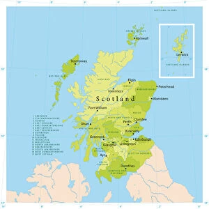
Scotland Road Map
A Scotland road map ideal for planning travel either for business or pleasure. Motorways, primary routes, A roads and many B roads are displayed on a green map base with full relief colouring (to give you an idea of hilly or mountainous areas). Scottish Unitary Authority and Council boundaries are shown along with major ferry routes, national parks, main airports and spot heights. Cities and towns are marked with six differing bands of town/city stamps based on population ranging from 2, 000 to 1, 000, 000 plus inhabitants. This Scotland map also includes an inset outlining Scottish Postcode Areas along with a useful mileage chart which indicates distances between 22 British towns and cities
Media ID 19951689
© Map Marketing Ltd
Photo Mug
A personalised photo mug blends sentimentality with functionality, making an ideal gift for cherished loved ones, close friends, or valued colleagues. Preview may show both sides of the same mug.
Elevate your coffee or tea experience with our premium white ceramic mug. Its wide, comfortable handle makes drinking easy, and you can rely on it to be both microwave and dishwasher safe. Sold in single units, preview may show both sides of the same mug so you can see how the picture wraps around.
Mug Size is 9.5cm high x 8cm diameter (3.7" x 3.1")
These are individually made so all sizes are approximate
FEATURES IN THESE COLLECTIONS
> Europe
> United Kingdom
> Scotland
> Maps
> Maps and Charts
> Related Images
MADE IN THE UK
Safe Shipping with 30 Day Money Back Guarantee
FREE PERSONALISATION*
We are proud to offer a range of customisation features including Personalised Captions, Color Filters and Picture Zoom Tools
SECURE PAYMENTS
We happily accept a wide range of payment options so you can pay for the things you need in the way that is most convenient for you
* Options may vary by product and licensing agreement. Zoomed Pictures can be adjusted in the Basket.