Acrylic Blox > Europe > United Kingdom > Scotland > Maps
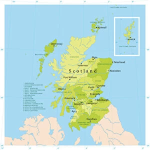
Acrylic Blox : Scotland Road Map


![]()
Mounted Prints from Map Marketing
Scotland Road Map
A Scotland road map ideal for planning travel either for business or pleasure. Motorways, primary routes, A roads and many B roads are displayed on a green map base with full relief colouring (to give you an idea of hilly or mountainous areas). Scottish Unitary Authority and Council boundaries are shown along with major ferry routes, national parks, main airports and spot heights. Cities and towns are marked with six differing bands of town/city stamps based on population ranging from 2, 000 to 1, 000, 000 plus inhabitants. This Scotland map also includes an inset outlining Scottish Postcode Areas along with a useful mileage chart which indicates distances between 22 British towns and cities
Media ID 19951689
© Map Marketing Ltd
8"x6" (20x15cm) Acrylic Blox
Your photographic print is held in place by magnets and a micro thin sheet of metal covering the back of a 20mm piece of clear acrylic. Your print is held in place with magnets so can easily be replaced if needed.
Streamlined, one sided modern and attractive table top print
Estimated Product Size is 15.2cm x 20.3cm (6" x 8")
These are individually made so all sizes are approximate
Artwork printed orientated as per the preview above, with portrait (vertical) orientation to match the source image.
FEATURES IN THESE COLLECTIONS
> Europe
> United Kingdom
> Scotland
> Maps
> Maps and Charts
> Related Images
MADE IN THE UK
Safe Shipping with 30 Day Money Back Guarantee
FREE PERSONALISATION*
We are proud to offer a range of customisation features including Personalised Captions, Color Filters and Picture Zoom Tools
SECURE PAYMENTS
We happily accept a wide range of payment options so you can pay for the things you need in the way that is most convenient for you
* Options may vary by product and licensing agreement. Zoomed Pictures can be adjusted in the Basket.