Photo Mug > Arts > Artists > B > Martin Behaim
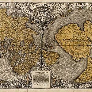
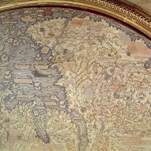
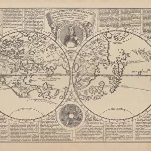
Photo Mug : MARTELLUS: WORLD MAP, 1489. World map, c1489, of Henricus Martellus, copies of


![]()
Home Decor from Granger
MARTELLUS: WORLD MAP, 1489. World map, c1489, of Henricus Martellus, copies of
MARTELLUS: WORLD MAP, 1489.
World map, c1489, of Henricus Martellus, copies of which are believed to have reached Christopher Columbus in Spain and Martin Behaim in Nuremberg where, in 1492, he constructed his terrestrial globe
Granger holds millions of images spanning more than 25,000 years of world history, from before the Stone Age to the dawn of the Space Age
Media ID 12320973
1489 Africa Age Of Discovery Asia Christopher Columbus Continent Europe Martin World Behaim Henricus
Photo Mug
Discover a unique blend of history and functionality with our Media Storehouse Photo Mugs featuring the captivating MARTELLUS: WORLD MAP, 1489. This exquisite design showcases a rare and intriguing world map, believed to have influenced the voyages of Christopher Columbus and Martin Behaim in the late 15th century. Each mug holds your favorite beverage while transporting you back in time, making every sip an adventure. Embrace the rich history of cartography and add a touch of antiquity to your daily routine with our Media Storehouse Photo Mugs.
A personalised photo mug blends sentimentality with functionality, making an ideal gift for cherished loved ones, close friends, or valued colleagues. Preview may show both sides of the same mug.
Elevate your coffee or tea experience with our premium white ceramic mug. Its wide, comfortable handle makes drinking easy, and you can rely on it to be both microwave and dishwasher safe. Sold in single units, preview may show both sides of the same mug so you can see how the picture wraps around.
Mug Size is 8cm high x 9.5cm diameter (3.1" x 3.7")
These are individually made so all sizes are approximate
FEATURES IN THESE COLLECTIONS
> Granger Art on Demand
> Maps
> Arts
> Artists
> B
> Martin Behaim
> Maps and Charts
> Related Images
> Maps and Charts
> Spain
> Maps and Charts
> World
EDITORS COMMENTS
The captivating print titled "MARTELLUS: WORLD MAP, 1489" takes us back in time to the Age of Discovery. This remarkable world map, created by Henricus Martellus in 1489, holds immense historical significance. It is believed that copies of this map reached Christopher Columbus in Spain and Martin Behaim in Nuremberg. As we gaze upon the intricate details of this ancient cartographic masterpiece, we are transported to a time when explorers were driven by curiosity and a thirst for knowledge. The map showcases the continents of Africa, Asia, and Europe with great precision for its era. It is fascinating to think that Christopher Columbus may have studied this very map before embarking on his famous voyage across the Atlantic Ocean. Similarly, Martin Behaim's construction of his terrestrial globe was likely influenced by Martellus' groundbreaking work. This print serves as a reminder of how maps have played an essential role throughout history - guiding adventurers through uncharted territories and expanding our understanding of the world. It symbolizes humanity's relentless pursuit of exploration and discovery. Whether you are a history enthusiast or simply appreciate artistry from centuries past, "MARTELLUS: WORLD MAP, 1489" offers a glimpse into an era where imagination met reality on vast rivers and distant shores.
MADE IN THE UK
Safe Shipping with 30 Day Money Back Guarantee
FREE PERSONALISATION*
We are proud to offer a range of customisation features including Personalised Captions, Color Filters and Picture Zoom Tools
SECURE PAYMENTS
We happily accept a wide range of payment options so you can pay for the things you need in the way that is most convenient for you
* Options may vary by product and licensing agreement. Zoomed Pictures can be adjusted in the Basket.