Photo Mug > Arts > Landscape paintings > Waterfall and river artworks > River artworks
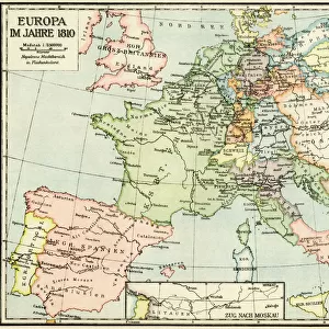
Photo Mug : MAP OF EUROPE, c1812. A 19th century German map of Europe during the reign of Napoleon I


![]()
Home Decor from Granger
MAP OF EUROPE, c1812. A 19th century German map of Europe during the reign of Napoleon I
MAP OF EUROPE, c1812. A 19th century German map of Europe during the reign of Napoleon I, c1812
Granger holds millions of images spanning more than 25,000 years of world history, from before the Stone Age to the dawn of the Space Age
Media ID 6616223
1810s 1812 Bonaparte Europe First French Empire
Photo Mug
"Add a touch of history to your daily routine with our Media Storehouse Photo Mugs featuring the captivating "Map of Europe, c1812" by The Granger Collection. This vintage map, showcasing Europe during the reign of Napoleon I, transports you back in time with its intricate details and historical significance. Each mug holds your favorite beverage while providing a fascinating conversation starter. Embrace the charm of history in every sip."
A personalised photo mug blends sentimentality with functionality, making an ideal gift for cherished loved ones, close friends, or valued colleagues. Preview may show both sides of the same mug.
Elevate your coffee or tea experience with our premium white ceramic mug. Its wide, comfortable handle makes drinking easy, and you can rely on it to be both microwave and dishwasher safe. Sold in single units, preview may show both sides of the same mug so you can see how the picture wraps around.
Mug Size is 8cm high x 9.5cm diameter (3.1" x 3.7")
These are individually made so all sizes are approximate
FEATURES IN THESE COLLECTIONS
> Granger Art on Demand
> Maps
> Arts
> Landscape paintings
> Waterfall and river artworks
> River artworks
> Europe
> Germany
> Related Images
> Europe
> Related Images
> Maps and Charts
> Early Maps
> Maps and Charts
> Related Images
EDITORS COMMENTS
This print showcases a remarkable piece of history - a 19th century German map of Europe, specifically depicting the region during the reign of Napoleon I in 1812. The intricate details and artistry captured in this print transport us back to a time when the first French Empire held sway over much of Europe. The map itself is an exquisite representation of its era, showcasing not only political boundaries but also highlighting major rivers that crisscrossed the continent. It serves as a testament to both the skill and precision with which cartographers worked during this period. As we gaze upon this historical artifact, we are reminded of the immense power wielded by Napoleon Bonaparte at his zenith. His influence extended far beyond France's borders, shaping the destiny of nations across Europe. This particular German map offers us insight into how European territories were organized under Napoleon's rule, providing valuable context for understanding geopolitical dynamics during that time. It serves as a visual reminder of an era marked by conflict and ambition, where empires rose and fell with each military campaign. Thanks to Granger Art on Demand's meticulous preservation efforts, we can now appreciate this stunning piece from our own homes. Whether you're an avid history enthusiast or simply captivated by vintage maps, this print is sure to spark curiosity and ignite your imagination about one of Europe's most transformative periods.
MADE IN THE UK
Safe Shipping with 30 Day Money Back Guarantee
FREE PERSONALISATION*
We are proud to offer a range of customisation features including Personalised Captions, Color Filters and Picture Zoom Tools
SECURE PAYMENTS
We happily accept a wide range of payment options so you can pay for the things you need in the way that is most convenient for you
* Options may vary by product and licensing agreement. Zoomed Pictures can be adjusted in the Basket.