Photo Mug > Africa > Namibia > Maps
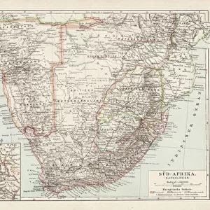
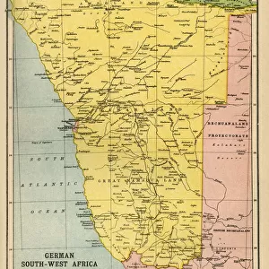
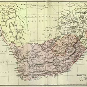
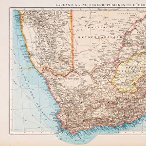
Photo Mug : Topographic map of South Africa and Namibia, lithograph, published 1897


![]()
Home Decor from Fine Art Storehouse
Topographic map of South Africa and Namibia, lithograph, published 1897
Topographic map of South Africa during the Dutch and British colonial era as well as Namibia (Deutsch-SAOEdwestafrika) during the German colonial era at the end of the 19th century. Lithograph, published in 1897
Unleash your creativity and transform your space into a visual masterpiece!
ZU_09
Media ID 18292305
Photo Mug
Step back in time with our unique Media Storehouse Photo Mug, featuring a captivating topographic map of South Africa and Namibia from 1897. This intricately detailed lithograph, published by ZU_09 from the Fine Art Storehouse, showcases the territories during the Dutch and British colonial era in South Africa and the German colonial era in Namibia (Deutsch-Südwestafrika). Perfect for history enthusiasts, avid collectors, or anyone who appreciates the beauty of vintage maps, this mug is not only a functional drinkware but also a stunning piece of art. Embrace the past with every sip.
A personalised photo mug blends sentimentality with functionality, making an ideal gift for cherished loved ones, close friends, or valued colleagues. Preview may show both sides of the same mug.
Elevate your coffee or tea experience with our premium white ceramic mug. Its wide, comfortable handle makes drinking easy, and you can rely on it to be both microwave and dishwasher safe. Sold in single units, preview may show both sides of the same mug so you can see how the picture wraps around.
Mug Size is 8cm high x 9.5cm diameter (3.1" x 3.7")
These are individually made so all sizes are approximate
FEATURES IN THESE COLLECTIONS
> Fine Art Storehouse
> Map
> Historical Maps
> Africa
> Namibia
> Related Images
> Africa
> Related Images
> Africa
> South Africa
> Maps
> Africa
> South Africa
> Related Images
> Europe
> Germany
> Related Images
EDITORS COMMENTS
This lithograph, titled "Topographic map of South Africa and Namibia" takes us on a journey back in time to the late 19th century. Published in 1897, it offers a fascinating glimpse into the colonial era that shaped these two African nations. The intricate details and meticulous craftsmanship of this print are truly commendable. The map showcases South Africa during its Dutch and British colonial period, highlighting the geographical features that defined this region's landscape at the time. From majestic mountain ranges to winding rivers and sprawling plains, every contour is meticulously depicted with precision. Additionally, we are transported to Namibia (then known as Deutsch-SAOEdwestafrika), which was under German colonial rule during this period. This inclusion provides an invaluable historical context for understanding the complex dynamics that influenced both countries' development. As we delve deeper into this lithograph, it becomes evident that it not only serves as a navigational tool but also as a visual testament to the rich history of these lands. It invites us to reflect upon how political forces have shaped their landscapes over time. Overall, ZU_09's "Topographic map of South Africa and Namibia" is more than just an artistic creation; it is a window into our past—a reminder of how far we have come while acknowledging the legacies left behind by those who came before us.
MADE IN THE UK
Safe Shipping with 30 Day Money Back Guarantee
FREE PERSONALISATION*
We are proud to offer a range of customisation features including Personalised Captions, Color Filters and Picture Zoom Tools
SECURE PAYMENTS
We happily accept a wide range of payment options so you can pay for the things you need in the way that is most convenient for you
* Options may vary by product and licensing agreement. Zoomed Pictures can be adjusted in the Basket.