Photo Mug > Europe > United Kingdom > Scotland > Maps
Photo Mug : Antique map of Scotland


![]()
Home Decor from Fine Art Storehouse
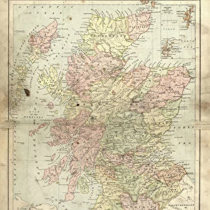
Antique map of Scotland
Antique map of Scotland, 1864
Unleash your creativity and transform your space into a visual masterpiece!
duncan1890
Media ID 13666661
© duncan1890
1860 1869 Aging Process Bad Condition Condition Image Created 1860 1869 Navigational Equipment Northern Europe Past Retro Revival Scotland Scottish Highlands Styles Highlands Region Image Created 19th Century Retro Styled Shetland Islands Victorian Style
Photo Mug
Introducing the Media Storehouse Photo Mug featuring an exquisite antique map of Scotland, beautifully captured by the talented artist Duncan1890 from our Fine Art Storehouse collection. Transport yourself back in time as you sip your favorite beverage from this captivating mug. The intricate details of the 1864 map design are brought to life, making each sip an adventure. Perfect for history enthusiasts or as a thoughtful gift, this mug is not only functional but also a work of art. Embrace the rich history of Scotland with every use.
A personalised photo mug blends sentimentality with functionality, making an ideal gift for cherished loved ones, close friends, or valued colleagues. Preview may show both sides of the same mug.
Elevate your coffee or tea experience with our premium white ceramic mug. Its wide, comfortable handle makes drinking easy, and you can rely on it to be both microwave and dishwasher safe. Sold in single units, preview may show both sides of the same mug so you can see how the picture wraps around.
Mug Size is 9.5cm high x 8cm diameter (3.7" x 3.1")
These are individually made so all sizes are approximate
FEATURES IN THESE COLLECTIONS
> Fine Art Storehouse
> Map
> Historical Maps
> Europe
> Related Images
> Europe
> United Kingdom
> Maps
> Europe
> United Kingdom
> Scotland
> Highlands
> Related Images
> Europe
> United Kingdom
> Scotland
> Maps
> Europe
> United Kingdom
> Scotland
> Posters
> Europe
> United Kingdom
> Scotland
> Related Images
> Maps and Charts
> Related Images
EDITORS COMMENTS
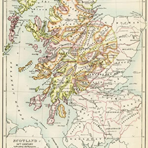
This print takes us back in time to the 19th century with its antique map of Scotland. Created in 1864, this engraved image showcases the rich history and intricate cartography of that era. Despite its bad condition due to aging, the retro revival style adds a touch of nostalgia and charm. The map highlights various regions including the Scottish Highlands and Shetland Islands, providing a glimpse into Northern Europe's past. Its vertical orientation allows for easy navigation and exploration using traditional navigational equipment from that time period. With its Victorian-style aesthetics, this print transports us to an era where maps were meticulously crafted works of art. The attention to detail is evident as we observe every line and curve on this historical piece. Although devoid of people, it reminds us of the importance maps held in guiding explorers through uncharted territories. It serves as a visual representation not only of Scotland's geography but also reflects the styles prevalent during that period. Duncan1890 has captured this stunning image, preserving a slice of history for all to appreciate. Whether you are an enthusiast or simply intrigued by the past, this photograph offers a unique opportunity to immerse yourself in 19th-century cartography and experience Scotland's beauty through an antique lens.
MADE IN THE UK
Safe Shipping with 30 Day Money Back Guarantee
FREE PERSONALISATION*
We are proud to offer a range of customisation features including Personalised Captions, Color Filters and Picture Zoom Tools
SECURE PAYMENTS
We happily accept a wide range of payment options so you can pay for the things you need in the way that is most convenient for you
* Options may vary by product and licensing agreement. Zoomed Pictures can be adjusted in the Basket.