Antique Framed Print > Europe > United Kingdom > Scotland > Maps
Antique Framed Print : Antique map of Scotland


![]()
Framed Photos from Fine Art Storehouse
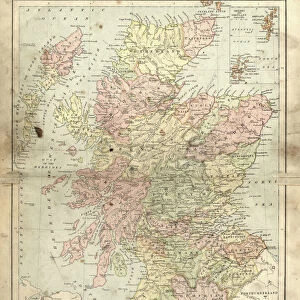
Antique map of Scotland
Antique map of Scotland, 1864
Unleash your creativity and transform your space into a visual masterpiece!
duncan1890
Media ID 13666661
© duncan1890
1860 1869 Aging Process Bad Condition Condition Image Created 1860 1869 Navigational Equipment Northern Europe Past Retro Revival Scotland Scottish Highlands Styles Highlands Region Image Created 19th Century Retro Styled Shetland Islands Victorian Style
14"x12" (36x31cm) Antique Frame
Bevelled wood effect frame, card mounted, 10x8 archival quality photo print. Overall outside dimensions 14x12 inches (36x31cm). Environmentally and ozone friendly, the Polycore® moulding has the look of real wood, is durable and light and easy to hang. Biodegradable and made with non-chlorinated gases (no toxic fumes) it is efficient; producing 100 tons of polystyrene can save 300 tons of trees! Prints are glazed with lightweight, shatterproof, optical clarity acrylic (providing the same general protection from the environment as glass). The back is stapled hardboard with a sawtooth hanger attached. Note: To minimise original artwork cropping, for optimum layout, and to ensure print is secure, the visible print may be marginally smaller
Bevelled Wood Effect Framed and Mounted Prints - Professionally Made and Ready to Hang
Estimated Image Size (if not cropped) is 19.5cm x 24.4cm (7.7" x 9.6")
Estimated Product Size is 31.2cm x 36.3cm (12.3" x 14.3")
These are individually made so all sizes are approximate
Artwork printed orientated as per the preview above, with portrait (vertical) orientation to match the source image.
FEATURES IN THESE COLLECTIONS
> Europe
> Related Images
> Europe
> United Kingdom
> Maps
> Europe
> United Kingdom
> Scotland
> Highlands
> Related Images
> Europe
> United Kingdom
> Scotland
> Maps
> Europe
> United Kingdom
> Scotland
> Posters
> Europe
> United Kingdom
> Scotland
> Related Images
> Maps and Charts
> Related Images
> Fine Art Storehouse
> Map
> Historical Maps
EDITORS COMMENTS
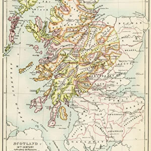
This print takes us back in time to the 19th century with its antique map of Scotland. Created in 1864, this engraved image showcases the rich history and intricate cartography of that era. Despite its bad condition due to aging, the retro revival style adds a touch of nostalgia and charm. The map highlights various regions including the Scottish Highlands and Shetland Islands, providing a glimpse into Northern Europe's past. Its vertical orientation allows for easy navigation and exploration using traditional navigational equipment from that time period. With its Victorian-style aesthetics, this print transports us to an era where maps were meticulously crafted works of art. The attention to detail is evident as we observe every line and curve on this historical piece. Although devoid of people, it reminds us of the importance maps held in guiding explorers through uncharted territories. It serves as a visual representation not only of Scotland's geography but also reflects the styles prevalent during that period. Duncan1890 has captured this stunning image, preserving a slice of history for all to appreciate. Whether you are an enthusiast or simply intrigued by the past, this photograph offers a unique opportunity to immerse yourself in 19th-century cartography and experience Scotland's beauty through an antique lens.
MADE IN THE UK
Safe Shipping with 30 Day Money Back Guarantee
FREE PERSONALISATION*
We are proud to offer a range of customisation features including Personalised Captions, Color Filters and Picture Zoom Tools
SECURE PAYMENTS
We happily accept a wide range of payment options so you can pay for the things you need in the way that is most convenient for you
* Options may vary by product and licensing agreement. Zoomed Pictures can be adjusted in the Basket.