Photo Mug > Arts > Artists > S > John Seller
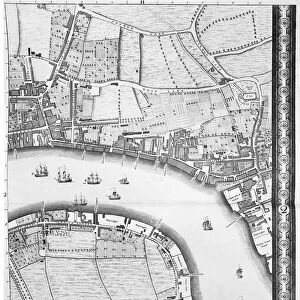
Photo Mug : A chart of the sea coasts of England, Flanders and Holland, c.1672 (print)
")
")

![]()
Home Decor from Fine Art Finder
A chart of the sea coasts of England, Flanders and Holland, c.1672 (print)
7340614 A chart of the sea coasts of England, Flanders and Holland, c.1672 (print) by Seller, John (1632-97); National Maritime Museum, London, UK; (add.info.: Creator: John Seller
From Atlas maritimus : or a book of charts describeing... most of the knowne parts of the world); © National Maritime Museum, Greenwich, London
Media ID 38412580
© © National Maritime Museum, Greenwich, London / Bridgeman Images
Coast Line Flanders Belgians Belgium Belgian Dutch Netherlands Hollander Hollanders Netherland Netherlands Holland Dutch The Netherland
Photo Mug
Sip your morning coffee in style with our Photo Mug featuring a stunning vintage map of the sea coasts of England, Flanders, and Holland from 1672. Perfect for history buffs and art lovers alike!
A personalised photo mug blends sentimentality with functionality, making an ideal gift for cherished loved ones, close friends, or valued colleagues. Preview may show both sides of the same mug.
Elevate your coffee or tea experience with our premium white ceramic mug. Its wide, comfortable handle makes drinking easy, and you can rely on it to be both microwave and dishwasher safe. Sold in single units, preview may show both sides of the same mug so you can see how the picture wraps around.
Mug Size is 8cm high x 9.5cm diameter (3.1" x 3.7")
These are individually made so all sizes are approximate
FEATURES IN THESE COLLECTIONS
> Fine Art Finder
> Artists
> John Rocque
> Fine Art Finder
> Artists
> John Seller
> Arts
> Artists
> S
> John Seller
> Europe
> Belgium
> Related Images
> Europe
> Netherlands
> Maps
> Europe
> Netherlands
> Posters
> Europe
> Netherlands
> Related Images
> Europe
> Republic of Ireland
> Maps
> Europe
> United Kingdom
> England
> London
> Boroughs
> Greenwich
> Europe
> United Kingdom
> England
> London
> Museums
> British Museum
EDITORS COMMENTS
This stunning print depicts a chart of the sea coasts of England, Flanders, and Holland from around 1672. Created by John Seller as part of his 'Atlas maritimus', this intricate map showcases the detailed coastlines and maritime features of these European regions during the 17th century.
The vibrant colors used in this print bring to life the coastal landscapes and seascapes, highlighting the importance of cartography in understanding navigation and trade routes during this period. The careful attention to detail in mapping out each coastline reflects Seller's dedication to accuracy and precision in his work.
As you gaze upon this historical artifact, you can almost feel yourself transported back in time to an era when exploration and discovery were at the forefront of human endeavor. The combination of artistry and scientific knowledge displayed in this print is truly awe-inspiring, reminding us of the rich history that lies behind every map ever created.
Whether you are a lover of history, geography, or simply appreciate fine craftsmanship, this print is sure to captivate your imagination and inspire a sense of wonder at the vastness and beauty of our world's coastlines.
MADE IN THE UK
Safe Shipping with 30 Day Money Back Guarantee
FREE PERSONALISATION*
We are proud to offer a range of customisation features including Personalised Captions, Color Filters and Picture Zoom Tools
SECURE PAYMENTS
We happily accept a wide range of payment options so you can pay for the things you need in the way that is most convenient for you
* Options may vary by product and licensing agreement. Zoomed Pictures can be adjusted in the Basket.