Photo Mug > Arts > Artists > L > Guillaume Le Testu
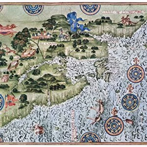
Photo Mug : F. 52v Map of Florida and the Antilles, from Cosmographia Universelle, 1555


![]()
Home Decor from Fine Art Finder
F. 52v Map of Florida and the Antilles, from Cosmographia Universelle, 1555
XIR159080 F.52v Map of Florida and the Antilles, from Cosmographia Universelle, 1555 (w/c on paper) by Le Testu, Guillaume (c.1509-73); Min. Defense - Service Historique de l Armee de Terre, France; French, out of copyright
Media ID 12733032
© www.bridgemanimages.com
Caribbean Chart Compass Cuba Dominican Republic Haiti Islands West Indies Natives
Photo Mug
Add a touch of history to your daily routine with our Media Storehouse Photo Mug featuring the intriguing F. 52v Map of Florida and the Antilles from Cosmographia Universelle, 1555. This exquisite map, created by Guillaume Le Testu, showcases the fascinating detail of early cartography. Each mug is expertly printed with archival-quality inks on a durable ceramic surface, ensuring your image remains vibrant and clear. Perfect for sipping your favorite beverage while exploring the wonders of the past.
A personalised photo mug blends sentimentality with functionality, making an ideal gift for cherished loved ones, close friends, or valued colleagues. Preview may show both sides of the same mug.
Elevate your coffee or tea experience with our premium white ceramic mug. Its wide, comfortable handle makes drinking easy, and you can rely on it to be both microwave and dishwasher safe. Sold in single units, preview may show both sides of the same mug so you can see how the picture wraps around.
Mug Size is 9.5cm high x 8cm diameter (3.7" x 3.1")
These are individually made so all sizes are approximate
FEATURES IN THESE COLLECTIONS
> Fine Art Finder
> Artists
> Guillaume Le Testu
> Fine Art Finder
> Maps (celestial & Terrestrial)
> Arts
> Artists
> L
> Guillaume Le Testu
EDITORS COMMENTS
This print showcases the F. 52v Map of Florida and the Antilles, a remarkable piece from the Cosmographia Universelle in 1555. Created by Guillaume Le Testu, a renowned French cartographer of the 16th century, this watercolor on paper artwork offers a glimpse into the intricate world of navigation during that era. The map depicts various islands including Haiti, Cuba, and the Dominican Republic along with other parts of North America. It features an array of fascinating elements such as flags representing different nations, ships sailing across vast oceans, compasses guiding explorers' paths, and detailed charts outlining geographical information. What makes this map truly intriguing is its portrayal of native inhabitants living within these lands. The inclusion of indigenous people sheds light on their existence before European colonization took place in these regions. This visual representation serves as a reminder to appreciate and respect diverse cultures that have shaped our world's history. Preserved by France's Ministry of Defense - Service Historique de l Armee de Terre, this historical artifact holds immense value for researchers and art enthusiasts alike. Its availability through Fine Art Finder allows us to delve into centuries-old cartography techniques while appreciating Le Testu's artistic prowess.
MADE IN THE UK
Safe Shipping with 30 Day Money Back Guarantee
FREE PERSONALISATION*
We are proud to offer a range of customisation features including Personalised Captions, Color Filters and Picture Zoom Tools
SECURE PAYMENTS
We happily accept a wide range of payment options so you can pay for the things you need in the way that is most convenient for you
* Options may vary by product and licensing agreement. Zoomed Pictures can be adjusted in the Basket.