Photo Mug > Maps and Charts > World
Photo Mug : Central Europe, 1914-1920 (colour litho)
")
")

![]()
Home Decor from Fine Art Finder
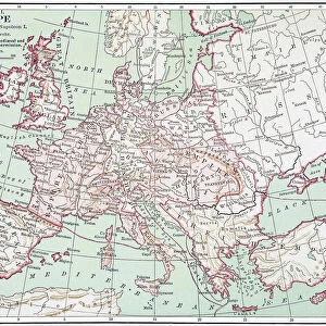
Central Europe, 1914-1920 (colour litho)
6008534 Central Europe, 1914-1920 (colour litho) by English School, (20th century); Private Collection; (add.info.: Central Europe, 1914-1920. Illustration for Harmsworths Atlas of the World and Pictorial Gazetteer edited by J A Hamerton (Amalgamated Press, c 1921).); © Look and Learn
Media ID 22332800
© Look and Learn / Bridgeman Images
1921 Atlas Central Europe Post Ww1 1920s 20s 20s Mythological Figure Pagan Paganism Pagans Polytheism Polytheist
Photo Mug
Bring a piece of history to your daily routine with our Media Storehouse Photo Mugs. Featuring the captivating Central Europe, 1914-1920 (colour litho) image by Bridgeman Images from Fine Art Finder. This stunning artwork, depicting Central Europe during the tumultuous years of 1914-1920, adds a touch of timeless elegance and intrigue to your mug. With vibrant colours and intricate details, this mug is not just a drinkware, but a work of art that tells a story. Perfect for tea or coffee, this mug is a must-have for history enthusiasts, art lovers, or anyone who appreciates the beauty of fine art.
A personalised photo mug blends sentimentality with functionality, making an ideal gift for cherished loved ones, close friends, or valued colleagues. Preview may show both sides of the same mug.
Elevate your coffee or tea experience with our premium white ceramic mug. Its wide, comfortable handle makes drinking easy, and you can rely on it to be both microwave and dishwasher safe. Sold in single units, preview may show both sides of the same mug so you can see how the picture wraps around.
Mug Size is 8cm high x 9.5cm diameter (3.1" x 3.7")
These are individually made so all sizes are approximate
FEATURES IN THESE COLLECTIONS
> Fine Art Finder
> Artists
> English Photographer
> Fine Art Finder
> Artists
> English School
> Maps and Charts
> Early Maps
> Maps and Charts
> Related Images
> Maps and Charts
> World
> Popular Themes
> Religious Images
Central Europe, 1914-1920 - A Glimpse into a Transformative Era
EDITORS COMMENTS
. This print titled "Central Europe, 1914-1920" offers a vivid portrayal of the region during a tumultuous period in history. Created by an anonymous English School artist in the early 20th century, this colour lithograph was featured in Harmsworths Atlas of the World and Pictorial Gazetteer edited by J. A. Hamerton. The image transports us back to a time when Central Europe was undergoing significant changes following the devastation of World War I. The map-like composition showcases various mythological figures and characters intertwined with symbols representing different religious beliefs and pagan traditions. This juxtaposition highlights the complex tapestry of cultures and ideologies that shaped Central Europe during this era. As we explore this artwork further, it becomes evident that it serves as more than just a geographical representation; it is also an exploration of mythology, religion, and historical context. It invites viewers to reflect on how these elements influenced society's collective consciousness at that time. With its vibrant colors and intricate details, this print captures both the chaos and resilience witnessed throughout Central Europe between 1914-1920. It stands as a testament to humanity's ability to adapt amidst adversity while reminding us of our shared past. Displayed here courtesy of Bridgeman Images' Fine Art Finder collection, this piece provides valuable insight into an important chapter in European history—a visual reminder for future generations about the transformative power
MADE IN THE UK
Safe Shipping with 30 Day Money Back Guarantee
FREE PERSONALISATION*
We are proud to offer a range of customisation features including Personalised Captions, Color Filters and Picture Zoom Tools
SECURE PAYMENTS
We happily accept a wide range of payment options so you can pay for the things you need in the way that is most convenient for you
* Options may vary by product and licensing agreement. Zoomed Pictures can be adjusted in the Basket.