Home > Europe > United Kingdom > England > Hampshire > Canada
EXPL2A-00357

![]()
Wall Art and Photo Gifts from North Wind
EXPL2A-00357
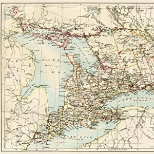
Map of the Great Lakes and the St. Lawrence watershed.
Printed color lithograph, 19th century
North Wind Picture Archives brings history to life with stock images and hand-colored illustrations
Media ID 5882115
© North Wind Picture Archives
Canada Canadian East Eastern French Canada Great Lakes Illinois Indiana Lake Lake Erie Lake Michigan Lake Ontario Lake Superior Maine Massachusetts Michigan Mid West Minnesota New England New Hampshire New York Northwest Territory Ohio Ontario Quebec River Water Way Wisconsin Lake Huron Manitoba North West Territory Saint Lawrence Seaway St Lawrence Watershed
FEATURES IN THESE COLLECTIONS
> Arts
> Landscape paintings
> Waterfall and river artworks
> River artworks
> Europe
> France
> Canton
> Maine
> Europe
> United Kingdom
> England
> Hampshire
> Canada
> Europe
> United Kingdom
> England
> Lakes
> Europe
> United Kingdom
> England
> Maps
> Europe
> United Kingdom
> England
> Rivers
> Europe
> United Kingdom
> England
> York
> North America
> Canada
> Lakes
> Lake Erie
> North America
> Canada
> Lakes
> Lake Huron
> North Wind Picture Archives
> Maps
EDITORS COMMENTS
This vintage print showcases the magnificent beauty and historical significance of the Great Lakes and the St. Lawrence watershed. Dating back to the 19th century, this printed color lithograph titled "EXPL2A-00357" offers a captivating illustration of this vast waterway system. The map encompasses a wide range of regions, from New York to Quebec, Ohio to Massachusetts, and even extends into Canadian provinces such as Ontario, Manitoba, and French Canada. It provides a comprehensive overview of the entire eastern region of North America during that era. With meticulous detail and artistic flair, this piece highlights not only the geographical features but also traces the rich history embedded within these waters. The Great Lakes - Superior, Michigan, Huron, Erie - stand out prominently on the map alongside Lake Ontario. The majestic St. Lawrence River meanders through various territories like an artery connecting these expansive bodies of water. As you delve into this artwork's intricate details, it becomes evident how crucial this waterway was for transportation and trade in both American and Canadian history. This print serves as a visual time capsule capturing an important period in our past when exploration and settlement were shaping these lands. Whether you are an art enthusiast or a history buff seeking to explore North America's early development further, this vintage print is sure to captivate your imagination with its charm and historical significance.
MADE IN THE UK
Safe Shipping with 30 Day Money Back Guarantee
FREE PERSONALISATION*
We are proud to offer a range of customisation features including Personalised Captions, Color Filters and Picture Zoom Tools
SECURE PAYMENTS
We happily accept a wide range of payment options so you can pay for the things you need in the way that is most convenient for you
* Options may vary by product and licensing agreement. Zoomed Pictures can be adjusted in the Basket.