Mouse Mat > Sheffield City Archives > Maps and Plans > Maps of Yorkshire
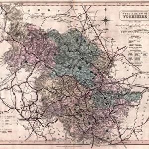
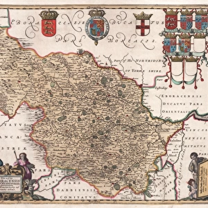
Mouse Mat : The West Riding of Yorkshire, 19th cent


![]()
Home Decor from Sheffield City Archives
The West Riding of Yorkshire, 19th cent
Scale 20 miles 1.4 inches.Original at Sheffield Libraries: y09456
Sheffield City Archives and Local Studies Library has an unrivalled collection of images of Sheffield, England
Media ID 14047653
© Sheffield City Council
Mouse Mat
A high quality photographic print manufactured into a durable wipe clean mouse mat (27x22cm) with a non slip backing, which works with all mice.
Archive quality photographic print in a durable wipe clean mouse mat with non slip backing. Works with all computer mice
Estimated Image Size (if not cropped) is 25.4cm x 21.8cm (10" x 8.6")
Estimated Product Size is 26.9cm x 21.8cm (10.6" x 8.6")
These are individually made so all sizes are approximate
Artwork printed orientated as per the preview above, with landscape (horizontal) orientation to match the source image.
EDITORS COMMENTS
This print takes us back in time to the 19th century, offering a glimpse into the enchanting West Riding of Yorkshire. The image showcases a meticulously detailed map, meticulously preserved by Sheffield Libraries and now housed at Sheffield City Archives under reference number y09456. With a scale of 20 miles per 1.4 inches, this remarkable piece allows us to explore the vast expanse of this historic region. The West Riding of Yorkshire comes alive through this visual representation, revealing its diverse landscapes and charming towns that once thrived within its borders. From rolling hills adorned with lush greenery to bustling market towns nestled along winding rivers, every inch of this map tells a story waiting to be discovered. As we delve deeper into the intricate details captured on this print, it becomes evident that it holds immense historical significance for researchers and history enthusiasts alike. While not intended for commercial use, it serves as an invaluable resource for understanding the development and evolution of Yorkshire's landscape over time. Sheffield Libraries deserves commendation for their dedication in preserving such treasures from our past. This photograph offers us a unique opportunity to appreciate the rich heritage embedded within these maps while igniting our curiosity about what life was like during those bygone days in one of England's most picturesque regions - The West Riding of Yorkshire.
MADE IN THE UK
Safe Shipping with 30 Day Money Back Guarantee
FREE PERSONALISATION*
We are proud to offer a range of customisation features including Personalised Captions, Color Filters and Picture Zoom Tools
SECURE PAYMENTS
We happily accept a wide range of payment options so you can pay for the things you need in the way that is most convenient for you
* Options may vary by product and licensing agreement. Zoomed Pictures can be adjusted in the Basket.