Mouse Mat > Granger Art on Demand > Maps
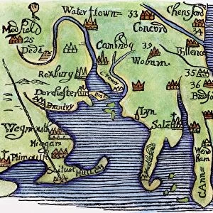
Mouse Mat : MAP OF NEW ENGLAND, 1677. Detail of a woodcut map of New England from William Hubbard s
![]()

Home Decor from Granger
MAP OF NEW ENGLAND, 1677. Detail of a woodcut map of New England from William Hubbard s
MAP OF NEW ENGLAND, 1677.
Detail of a woodcut map of New England from William Hubbards Narrative of the Troubles in New England, 1677. This is thought to be the first map cut in the colony
Granger holds millions of images spanning more than 25,000 years of world history, from before the Stone Age to the dawn of the Space Age
Media ID 12321052
1677 Alliance Coast Colonist Colony Detail Hubbard Massachusetts Metacomet Mohawk Narragansett Nipmuck Philip Pilgrim Rebellion United States Wampanoag William
Mouse Mat
A high quality photographic print manufactured into a durable wipe clean mouse mat (27x22cm) with a non slip backing, which works with all mice.
Archive quality photographic print in a durable wipe clean mouse mat with non slip backing. Works with all computer mice
Estimated Image Size (if not cropped) is 25.4cm x 21.8cm (10" x 8.6")
Estimated Product Size is 26.9cm x 21.8cm (10.6" x 8.6")
These are individually made so all sizes are approximate
Artwork printed orientated as per the preview above, with landscape (horizontal) orientation to match the source image.
EDITORS COMMENTS
This print showcases a remarkable piece of history - the "Map of New England, 1677". With its intricate woodcut details, this map is believed to be the first ever cut in the colony. The map was featured in William Hubbard's Narrative of the Troubles in New England, providing a visual representation of this tumultuous period. As we delve into this snapshot from the past, we are transported to a time when America was still forging its identity. The map highlights key locations along the eastern coast, including Massachusetts and Narragansett Bay. It offers insight into early colonial settlements and their interactions with indigenous tribes such as Wampanoag, Mohawk, and Nipmuck. One cannot overlook the significance of this map during a time marked by rebellion. Just prior to its creation, King Philip's War had ravaged these lands as Native American leader Metacomet (also known as King Philip) led an uprising against colonists. This conflict forever altered relationships between settlers and indigenous communities. The Map of New England serves not only as a historical artifact but also as a testament to exploration and discovery during America's formative years. It symbolizes unity among colonists who sought to establish themselves on foreign shores while navigating complex alliances with various tribes. Through this print from Granger Art on Demand, we can appreciate both the artistry behind woodcut maps and their invaluable role in documenting our shared heritage.
MADE IN THE UK
Safe Shipping with 30 Day Money Back Guarantee
FREE PERSONALISATION*
We are proud to offer a range of customisation features including Personalised Captions, Color Filters and Picture Zoom Tools
SECURE PAYMENTS
We happily accept a wide range of payment options so you can pay for the things you need in the way that is most convenient for you
* Options may vary by product and licensing agreement. Zoomed Pictures can be adjusted in the Basket.


