Mounted Print > Africa > South Africa > Maps
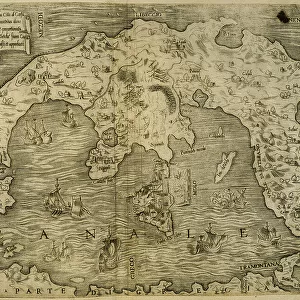
Mounted Print : Map of South Africa


![]()
Mounted Prints from Universal Images Group (UIG)
Map of South Africa
Universal Images Group (UIG) manages distribution for many leading specialist agencies worldwide
Media ID 9539913
© Dorling Kindersley/UIG
10"x8" Mount with 8"x6" Print
Introducing the stunning addition to your home decor from Media Storehouse - our Mounted Photos featuring the intricately detailed Map of South Africa by Dorling Kindersley from Universal Images Group (UIG). This beautiful, high-quality mounted print showcases the diverse landscapes, cities, and geographical features of the Rainbow Nation. Bring the rich culture and history of South Africa into your living space with this captivating and conversation-starting piece. Order yours today and make a statement in your home or office.
Printed on 8"x6" paper and suitable for use in a 10"x8" frame (frame not included). Prints are mounted with card both front and back. Featuring a custom cut aperture to match chosen image. Professional 234gsm Fujifilm Crystal Archive DP II paper.
Photo prints supplied in custom cut card mount ready for framing
Estimated Image Size (if not cropped) is 17.9cm x 15.2cm (7" x 6")
Estimated Product Size is 25.4cm x 20.3cm (10" x 8")
These are individually made so all sizes are approximate
Artwork printed orientated as per the preview above, with landscape (horizontal) orientation to match the source image.
FEATURES IN THESE COLLECTIONS
> Africa
> South Africa
> Maps
> Africa
> South Africa
> Related Images
> Maps and Charts
> Related Images
> Universal Images Group (UIG)
> Illustrations
> Illustrations 1
EDITORS COMMENTS
This print showcases the vibrant and diverse beauty of South Africa, a country that never fails to enchant with its rich history and breathtaking landscapes. The "Map of South Africa" by Dorling Kindersley, brought to life in this illustration, is an invitation to embark on a visual journey through this African gem. The map itself is a testament to the intricate artistry of cartography, meticulously crafted with attention to detail. It effortlessly captures the vastness of South Africa's geography, from its rugged mountains and lush forests to its expansive coastlines and arid deserts. Every region comes alive in vivid colors, allowing viewers to immerse themselves in the sheer diversity that defines this remarkable nation. As we gaze upon this image, our imagination takes flight as we envision traversing across iconic landmarks such as Table Mountain or exploring world-renowned national parks like Kruger. This map serves not only as a navigational tool but also as an inspiration for intrepid travelers seeking adventure within South Africa's borders. Dorling Kindersley's expertise shines through their skillful portrayal of South Africa's essence - both visually stunning and informative. Whether you are planning your next trip or simply yearning for an escape into uncharted territories from the comfort of your home, this print promises an exhilarating glimpse into one of Africa's most captivating countries: South Africa.
MADE IN THE UK
Safe Shipping with 30 Day Money Back Guarantee
FREE PERSONALISATION*
We are proud to offer a range of customisation features including Personalised Captions, Color Filters and Picture Zoom Tools
SECURE PAYMENTS
We happily accept a wide range of payment options so you can pay for the things you need in the way that is most convenient for you
* Options may vary by product and licensing agreement. Zoomed Pictures can be adjusted in the Basket.