Mounted Print > Maps and Charts > World
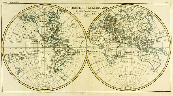
Mounted Print : Map of World circa. 1760. From Atlas de Toutes Les Parties Connues du Globe Terrestre
![]()

Mounted Prints from Universal Images Group (UIG)
Map of World circa. 1760. From Atlas de Toutes Les Parties Connues du Globe Terrestre
Map of World circa.1760. From Atlas de Toutes Les Parties Connues du Globe Terrestre by Cartographer Rigobert Bonne. Published Geneva circa. 1760
Universal Images Group (UIG) manages distribution for many leading specialist agencies worldwide
Media ID 20165267
© Universal Images Group
Color Colour Mapmaking Plate Welsh
10"x8" Mount with 8"x6" Print
Step back in time with our exquisite Mounted Photos featuring a captivating Map of the World circa. 1760. This antique cartographic masterpiece is derived from Rigobert Bonne's Atlas de Toutes Les Parties Connues du Globe Terrestre, published in Geneva around 1760. The intricate details of this map showcase the geographical knowledge of the time, making it an essential addition to any history or cartography enthusiast's collection. Our high-quality Mounted Photos preserve the authenticity and beauty of this rare map, ensuring it remains a stunning conversation starter in your home or office.
Printed on 8"x6" paper and suitable for use in a 10"x8" frame (frame not included). Prints are mounted with card both front and back. Featuring a custom cut aperture to match chosen image. Professional 234gsm Fujifilm Crystal Archive DP II paper.
Photo prints supplied in custom cut card mount ready for framing
Estimated Image Size (if not cropped) is 20.3cm x 11.2cm (8" x 4.4")
Estimated Product Size is 25.4cm x 20.3cm (10" x 8")
These are individually made so all sizes are approximate
Artwork printed orientated as per the preview above, with landscape (horizontal) orientation to match the source image.
FEATURES IN THESE COLLECTIONS
> Maps and Charts
> Related Images
> Maps and Charts
> World
> Universal Images Group (UIG)
> History
> Historical Maps
EDITORS COMMENTS
This print showcases a remarkable piece of history - the "Map of World circa. 1760". From the renowned Atlas de Toutes Les Parties Connues du Globe Terrestre, meticulously crafted by the skilled cartographer Rigobert Bonne and published in Geneva around 1760. With its horizontal orientation, vibrant colors, and intricate details, this map is truly a work of art. It takes us back to an era when explorers embarked on daring voyages across uncharted territories, expanding our understanding of the world we inhabit. The illustration offers a glimpse into the geography of that time, depicting continents and oceans with utmost precision. Every line etched onto this plate engraving tells a story - from mountain ranges majestically rising to rivers meandering through vast landscapes. As we gaze upon this masterpiece, we are reminded of the immense effort put forth by Welsh cartographer Ken in his pursuit of accurate mapmaking. His dedication shines through every stroke on this map. Transporting us back to an age where knowledge was still being discovered and shared, this photograph invites us to marvel at how far humanity has come since then. It serves as a reminder that our world is ever-evolving and constantly shaped by those who dare to explore its boundaries. Through Universal Images Group's lens capturing this extraordinary artifact from Universal History Archive's collection (UIG), we can appreciate not only its historical significance but also its enduring beauty as an invaluable piece of human achievement.
MADE IN THE UK
Safe Shipping with 30 Day Money Back Guarantee
FREE PERSONALISATION*
We are proud to offer a range of customisation features including Personalised Captions, Color Filters and Picture Zoom Tools
SECURE PAYMENTS
We happily accept a wide range of payment options so you can pay for the things you need in the way that is most convenient for you
* Options may vary by product and licensing agreement. Zoomed Pictures can be adjusted in the Basket.


