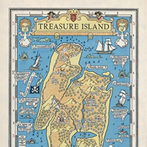
Mounted Print > Maps and Charts > World
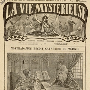
Mounted Print : NOSTRADAMUS - CLIMATA Nostradamus frequently made references to places by way of


![]()
Mounted Prints from TopFoto
NOSTRADAMUS - CLIMATA Nostradamus frequently made references to places by way of
NOSTRADAMUS - CLIMATA
Nostradamus frequently made references to places by way of latitudes (in the 16th century normally called climata) familiar to him from ancient literature. This map of the World, as it was known to Stabo, offers an example of how remote from the modern visualisation the ancient realm was, and how inappropriate it is to translate the climata in terms merely of latitudes
TopFoto independent historic photographs and images all subjects and eras
Media ID 10975883
© 2003 Charles Walker / Topham
10"x8" Mount with 8"x6" Print
Step into the mystical world of Nostradamus with our stunningly detailed Mounted Photos from Media Storehouse. Featuring an evocative image of the famous seer, these mounted prints bring the enigmatic figure of Nostradamus to life. Known for his prophetic verses, Nostradamus often referred to places through ancient latitudes, or climata. Bring the intrigue of the 16th century into your home or office with this captivating mounted photo of Nostradamus. Order yours today and unlock the secrets of the past.
Printed on 8"x6" paper and suitable for use in a 10"x8" frame (frame not included). Prints are mounted with card both front and back. Featuring a custom cut aperture to match chosen image. Professional 234gsm Fujifilm Crystal Archive DP II paper.
Photo prints supplied in custom cut card mount ready for framing
Estimated Image Size (if not cropped) is 20.3cm x 13.2cm (8" x 5.2")
Estimated Product Size is 25.4cm x 20.3cm (10" x 8")
These are individually made so all sizes are approximate
Artwork printed orientated as per the preview above, with landscape (horizontal) orientation to match the source image.
FEATURES IN THESE COLLECTIONS
> Arts
> Literature
> Maps and Charts
> Early Maps
> Maps and Charts
> Related Images
> Maps and Charts
> World
> TopFoto
> Man, Myth and Magic
EDITORS COMMENTS
This print titled "NOSTRADAMUS - CLIMATA" takes us back to the 16th century, when Nostradamus frequently referred to places using latitudes known as climata. The map depicted in the photograph represents the ancient world as understood by Stabo, showcasing just how different it was from our modern visualization. Nostradamus, renowned for his esoteric and paranormal predictions, often drew inspiration from ancient literature. This map serves as a testament to his deep knowledge of historical geography and his ability to connect past and present. The image transports us into a realm where mystical forces intertwine with earthly locations. It invites us to ponder on the enigmatic mind of Nostradamus and his unique perspective on time and space. While this print does not mention any commercial use or affiliation with a specific company, it captures the essence of Nostradamus' legacy beyond monetary gain. Instead, it offers an opportunity for contemplation and exploration of the unknown. Whether you are fascinated by history, astrology, or simply intrigued by Nostradamus' prophecies, this mesmerizing image is sure to spark your imagination. Let yourself be transported back in time through this intriguing visual representation of climata – a window into both ancient wisdom and future possibilities.
MADE IN THE UK
Safe Shipping with 30 Day Money Back Guarantee
FREE PERSONALISATION*
We are proud to offer a range of customisation features including Personalised Captions, Color Filters and Picture Zoom Tools
SECURE PAYMENTS
We happily accept a wide range of payment options so you can pay for the things you need in the way that is most convenient for you
* Options may vary by product and licensing agreement. Zoomed Pictures can be adjusted in the Basket.