Mounted Print > Arts > Artists > C > Samuel de Champlain
Mounted Print : EXPL2A-00184


![]()
Mounted Prints from North Wind
EXPL2A-00184
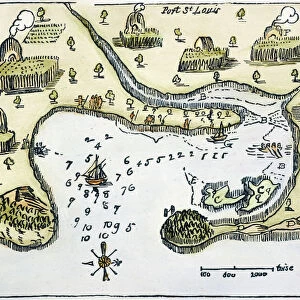
Part of the 1613 Samuel de Champlain map of New France.
Hand-colored woodcut of a 19th-century reproduction of the original ma
North Wind Picture Archives brings history to life with stock images and hand-colored illustrations
Media ID 5879600
© North Wind Picture Archives
1600s 17th Century Atlantic Canada Canadian Cartography Champlain Colonial Colony Discover Exploration Explore French French Canada Gaspee Lake Lake Champlain Maine Massachusetts New England New France New World New York Newfoundland Nova Scotia Ocean Quebec River Samuel De Champlain St Lawrence River Vermont 1613 Hudson Bay Prince Edward Island
10"x8" Mount with 8"x6" Print
Introducing the Media Storehouse Mounted Photos, featuring EXPL2A-00184 from North Wind Picture Archives. This captivating image is a hand-colored woodcut taken from the 1613 Samuel de Champlain map of New France. Transport yourself back in time with this intricately detailed 19th-century reproduction, now beautifully mounted and ready to be displayed in your home or office. Each Mounted Photo is meticulously crafted with high-quality materials, ensuring a stunning and long-lasting presentation of this historical treasure. Elevate your space with a touch of history and culture - order your Media Storehouse Mounted Photo today!
Printed on 8"x6" paper and suitable for use in a 10"x8" frame (frame not included). Prints are mounted with card both front and back. Featuring a custom cut aperture to match chosen image. Professional 234gsm Fujifilm Crystal Archive DP II paper.
Photo prints supplied in custom cut card mount ready for framing
Estimated Image Size (if not cropped) is 20.3cm x 10.9cm (8" x 4.3")
Estimated Product Size is 25.4cm x 20.3cm (10" x 8")
These are individually made so all sizes are approximate
Artwork printed orientated as per the preview above, with landscape (horizontal) orientation to match the source image.
FEATURES IN THESE COLLECTIONS
> Arts
> Artists
> C
> Samuel de Champlain
> Arts
> Artists
> L
> Samuel Lawrence
> Arts
> Artists
> O
> Oceanic Oceanic
> Arts
> Landscape paintings
> Waterfall and river artworks
> River artworks
> Europe
> France
> Canton
> Maine
> Europe
> France
> Lakes
> Related Images
> Europe
> United Kingdom
> England
> Lakes
> Europe
> United Kingdom
> England
> Maps
> Europe
> United Kingdom
> England
> Rivers
> North Wind Picture Archives
> Canadian history
> North Wind Picture Archives
> Maps
EDITORS COMMENTS
This print showcases a piece of history, the EXPL2A-00184 map by Samuel de Champlain. Dating back to 1613, this hand-colored woodcut is a remarkable reproduction from the 19th century. The intricate details and vibrant colors bring to life the original map of New France. The map encompasses various regions, including parts of present-day United States and Canada. It highlights significant locations such as Lake Champlain, Quebec, Massachusetts, Newfoundland, Hudson Bay, Nova Scotia, and many more. This cartographic masterpiece offers a glimpse into the exploration and colonization era of North America during the 17th century. With its vintage aesthetic and artistic flair, this print evokes a sense of nostalgia for those fascinated by historical maps. It serves as a visual portal to an era when French explorers like Champlain ventured across uncharted territories in search of new lands. As we gaze upon this artwork today, it reminds us of our rich heritage and how these early discoveries shaped both American and Canadian history. Whether displayed in homes or educational institutions alike, this unique illustration invites viewers to delve into the past while appreciating the artistry behind it
MADE IN THE UK
Safe Shipping with 30 Day Money Back Guarantee
FREE PERSONALISATION*
We are proud to offer a range of customisation features including Personalised Captions, Color Filters and Picture Zoom Tools
SECURE PAYMENTS
We happily accept a wide range of payment options so you can pay for the things you need in the way that is most convenient for you
* Options may vary by product and licensing agreement. Zoomed Pictures can be adjusted in the Basket.