Mounted Print > Animals > Mammals > Cricetidae > California Mouse
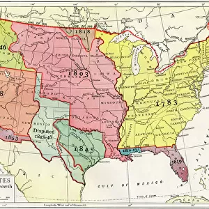
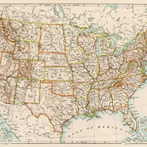
Mounted Print : U. S. territory gained from Mexico


![]()
Mounted Prints from North Wind
U. S. territory gained from Mexico
Map of territory acquired by the U.S. from Mexico.
Color lithograph of a 19th-century illustration
North Wind Picture Archives brings history to life with stock images and hand-colored illustrations
Media ID 5877444
© North Wind Picture Archives
America Border Boundary California Mexican Mexican War Mexico Oregon Oregon Territory States Territory Texas West Western
10"x8" Mount with 8"x6" Print
Step back in time and explore the rich history of U.S. expansion with our stunning mounted photo from the North Wind Picture Archives. This captivating color lithograph depicts the U.S. territory gained from Mexico during the 19th century, a significant moment in American history. Each mounted photo in the Media Storehouse range is meticulously preserved and presented on high-quality, archival-grade mounting material, ensuring your historical treasure remains protected and proudly displayed for generations to come. Add this unique and educational piece to your collection and bring a piece of history into your home or office.
Printed on 8"x6" paper and suitable for use in a 10"x8" frame (frame not included). Prints are mounted with card both front and back. Featuring a custom cut aperture to match chosen image. Professional 234gsm Fujifilm Crystal Archive DP II paper.
Photo prints supplied in custom cut card mount ready for framing
Estimated Image Size (if not cropped) is 13.7cm x 20.3cm (5.4" x 8")
Estimated Product Size is 20.3cm x 25.4cm (8" x 10")
These are individually made so all sizes are approximate
Artwork printed orientated as per the preview above, with portrait (vertical) orientation to match the source image.
FEATURES IN THESE COLLECTIONS
> Animals
> Mammals
> Cricetidae
> California Mouse
> Animals
> Mammals
> Muridae
> Western Mouse
> Maps and Charts
> Related Images
> North America
> Mexico
> Maps
> North America
> Mexico
> Related Images
> North America
> Related Images
> North Wind Picture Archives
> American history
> North Wind Picture Archives
> Maps
EDITORS COMMENTS
This print showcases a historically significant map of U. S. territory gained from Mexico during the 19th century. The color lithograph, based on an illustration from that era, transports us back in time to witness the expansion of American borders and the shaping of our nation's heritage. The image reveals a vast expanse of land stretching across North America, highlighting key regions acquired through various means such as treaties and military conquests. From the western territories like California and Oregon to Texas along the southern border, this map represents a pivotal period in American history. With its vintage charm and intricate details, this artful depiction invites us to explore the boundaries that were redrawn during this transformative era. It serves as a visual testament to both triumphs and conflicts that shaped our country's identity. As we gaze upon this piece, we are reminded not only of territorial gains but also of the complex relationships between nations. The Mexican-American War and subsequent negotiations like the Gadsden Purchase come alive through this historical artifact. Whether you are an avid history enthusiast or simply appreciate art with cultural significance, this print offers a unique glimpse into America's past - reminding us how far we have come while honoring those who paved the way for future generations.
MADE IN THE UK
Safe Shipping with 30 Day Money Back Guarantee
FREE PERSONALISATION*
We are proud to offer a range of customisation features including Personalised Captions, Color Filters and Picture Zoom Tools
SECURE PAYMENTS
We happily accept a wide range of payment options so you can pay for the things you need in the way that is most convenient for you
* Options may vary by product and licensing agreement. Zoomed Pictures can be adjusted in the Basket.