Mounted Print > Maps and Charts > World
Mounted Print : Maps / World / Herodotus


![]()
Mounted Prints from Mary Evans Picture Library
Maps / World / Herodotus
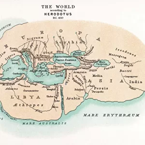
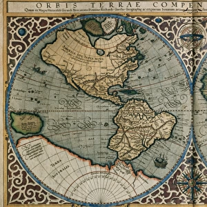
The world as known to Herodotus
Mary Evans Picture Library makes available wonderful images created for people to enjoy over the centuries
Media ID 581519
© Mary Evans Picture Library 2015 - https://copyrighthub.org/s0/hub1/creation/maryevans/MaryEvansPictureID/10027527
10"x8" Mount with 8"x6" Print
Step back in time and explore the world as known to ancient Greek historian Herodotus with our stunning range of Mounted Photos from Media Storehouse, exclusively available at Mary Evans Prints Online. These beautifully crafted, museum-quality prints feature intricately detailed maps and illustrations of the world as described by Herodotus in his seminal works. Each print is meticulously mounted on high-quality archival board, ensuring longevity and preservation. Bring history to life in your home or office with these captivating and educational pieces.
Printed on 8"x6" paper and suitable for use in a 10"x8" frame (frame not included). Prints are mounted with card both front and back. Featuring a custom cut aperture to match chosen image. Professional 234gsm Fujifilm Crystal Archive DP II paper.
Photo prints supplied in custom cut card mount ready for framing
Estimated Image Size (if not cropped) is 20.3cm x 14.3cm (8" x 5.6")
Estimated Product Size is 25.4cm x 20.3cm (10" x 8")
These are individually made so all sizes are approximate
Artwork printed orientated as per the preview above, with landscape (horizontal) orientation to match the source image.
FEATURES IN THESE COLLECTIONS
> Maps and Charts
> Early Maps
> Maps and Charts
> Related Images
> Maps and Charts
> World
EDITORS COMMENTS
This print depicts the world as it was known to the ancient Greek historian Herodotus around 450 BC. Herodotus, often referred to as the "Father of History," is renowned for his groundbreaking work "The Histories," an account of the Persian Wars and the world known to the Greeks during that time. The map, based on Herodotus' descriptions, presents a fascinating glimpse into the geographical knowledge of the ancient world. Herodotus' descriptions were primarily based on firsthand accounts and oral traditions, as he traveled extensively throughout Greece, Egypt, and other parts of the ancient world. His work includes detailed information about various cities, rivers, mountains, and peoples, many of which are depicted in this map. The map is divided into three continents: Europe, Asia, and Libya (Africa). The Mediterranean Sea dominates the center of the map, with the Black Sea and the Red Sea also depicted. The Nile River, the longest river known to the ancient world, flows through Egypt and is shown winding its way through the desert. The print also includes various labels indicating major cities, such as Athens, Sparta, Babylon, and Memphis, as well as significant landmarks, such as the Pillars of Heracles (modern-day Gibraltar) and the Caspian Sea. The map also shows the known extent of the Persian Empire, which was the largest empire of the ancient world at that time. This print is an invaluable resource for scholars and history enthusiasts, providing a unique window into the world as it was known to one of the greatest historians in human history. It serves as a reminder of the incredible feats of exploration and discovery that have shaped our understanding of the world and our place in it.
MADE IN THE UK
Safe Shipping with 30 Day Money Back Guarantee
FREE PERSONALISATION*
We are proud to offer a range of customisation features including Personalised Captions, Color Filters and Picture Zoom Tools
SECURE PAYMENTS
We happily accept a wide range of payment options so you can pay for the things you need in the way that is most convenient for you
* Options may vary by product and licensing agreement. Zoomed Pictures can be adjusted in the Basket.