Home > Maps and Charts > World
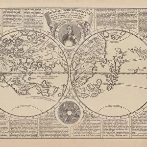
World map by Claudius Ptolemy (90-168). Engraving, 16th cent
. Engraving, 16th cent")
![]()
Wall Art and Photo Gifts from Mary Evans Picture Library
World map by Claudius Ptolemy (90-168). Engraving, 16th cent
Claudius Ptolemy (90-168) Greco-Egyptian geographer. World map. Engraving, 16th century
Mary Evans Picture Library makes available wonderful images created for people to enjoy over the centuries
Media ID 14337098
© Thaliastock / Mary Evans
Astronomer Cartography Claudius Earth Geographer Geography Globe Hellenistic Ptolemy Renaissance
FEATURES IN THESE COLLECTIONS
> Europe
> Related Images
> Maps and Charts
> Early Maps
> Maps and Charts
> World
EDITORS COMMENTS
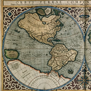
This engraving showcases the world map as it was understood during the Renaissance period, based on the groundbreaking work of the ancient Greco-Egyptian scholar Claudius Ptolemy (90-168 AD). A renowned astronomer, geographer, and mathematician, Ptolemy's geographical theories and methods significantly influenced Western cartography for centuries to come. Ptolemy's original work, "Geographia," was compiled around 150 AD and contained descriptions of the known world, along with 270 maps and a series of six maps depicting the entire world. However, these maps did not survive into the Renaissance. Instead, European cartographers relied on the works of Ptolemy's later followers, such as the Syrian geographer Ptolemy of Alexandria, who produced a revised and expanded version of Ptolemy's maps in the 15th century. The engraving before you is a testament to the enduring influence of Ptolemy's ideas. It displays the world as divided into five continents: Europe, Asia, Africa, the Americas, and Australia (which was not yet discovered). The map includes various details, such as rivers, mountains, and cities, based on the knowledge available during the 16th century. This map holds significant historical value, as it reflects the state of geographical knowledge during the Renaissance, a period marked by a renewed interest in the classical world and a surge in exploration and discovery. The map's intricate details and captivating design serve as a reminder of the intellectual curiosity and ingenuity that characterized this era.
MADE IN THE UK
Safe Shipping with 30 Day Money Back Guarantee
FREE PERSONALISATION*
We are proud to offer a range of customisation features including Personalised Captions, Color Filters and Picture Zoom Tools
SECURE PAYMENTS
We happily accept a wide range of payment options so you can pay for the things you need in the way that is most convenient for you
* Options may vary by product and licensing agreement. Zoomed Pictures can be adjusted in the Basket.