Mounted Print > Maps and Charts > Early Maps
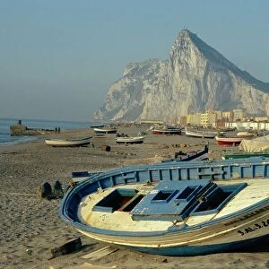
Mounted Print : Map of Gibraltar (XVIIIIth c. ). Etching
. Etching")
. Etching")


![]()
Mounted Prints from Mary Evans Picture Library
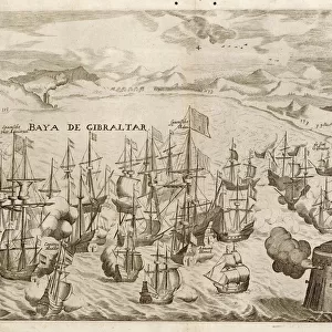
Map of Gibraltar (XVIIIIth c. ). Etching
Map of Gibraltar (XVIIIIth c.). Etching
Mary Evans Picture Library makes available wonderful images created for people to enjoy over the centuries
Media ID 8273425
© Mary Evans Picture Library 2015 - https://copyrighthub.org/s0/hub1/creation/maryevans/MaryEvansPictureID/10687011
Engravings Etching Etchings Geographic Geographical Geography Gibraltar Technical Technician Technicians Technique Techniques Technological Technology Transportations Transports
14"x12" Mount with 12"x10" Print
Discover history with our exquisite Media Storehouse Mounted Photos. This captivating piece features a rare etching of a Map of Gibraltar from the XVIIIIth century, sourced from the esteemed Mary Evans Prints Online. With intricate details and authenticity, this mounted photo brings the rich history of Gibraltar to your home or office. The etching showcases the strategic location of this iconic British Overseas Territory, transporting you back in time. Add this unique and educational addition to your collection and ignite your curiosity.
Printed on 12"x10" paper and suitable for use in a 14"x12" frame (frame not included). Prints are mounted with card both front and back. Featuring a custom cut aperture to match chosen image. Professional 234gsm Fujifilm Crystal Archive DP II paper.
Photo prints supplied in custom cut card mount ready for framing
Estimated Image Size (if not cropped) is 29.4cm x 25.4cm (11.6" x 10")
Estimated Product Size is 35.6cm x 30.5cm (14" x 12")
These are individually made so all sizes are approximate
Artwork printed orientated as per the preview above, with landscape (horizontal) orientation to match the source image.
FEATURES IN THESE COLLECTIONS
> Maps and Charts
> Early Maps
> Maps and Charts
> Related Images
EDITORS COMMENTS
This stunning print captures a historical map of Gibraltar from the XVIIth century, showcasing intricate details and vibrant colors. The etching technique used to create this map highlights the skilled craftsmanship and technical expertise of the artist.
The geographical accuracy of this map is impressive, providing a glimpse into the transportation routes and landmarks of Gibraltar during this time period. The historical significance of this piece is evident in its depiction of a bygone era, offering viewers a window into the past.
The horizontal layout of the map allows for easy navigation and study, making it an invaluable resource for historians and enthusiasts alike. The use of color adds depth and dimension to the etching, bringing each detail to life with precision.
Overall, this print serves as a testament to both the technological advancements of its time and the artistic talent required to produce such intricate engravings. It stands as a reminder of Gibraltar's rich history and cultural heritage, preserved through meticulous craftsmanship and attention to detail.
Whether displayed in a home or office setting, this Map of Gibraltar (XVIIth c.) Etching is sure to captivate viewers with its beauty and historical significance.
MADE IN THE UK
Safe Shipping with 30 Day Money Back Guarantee
FREE PERSONALISATION*
We are proud to offer a range of customisation features including Personalised Captions, Color Filters and Picture Zoom Tools
SECURE PAYMENTS
We happily accept a wide range of payment options so you can pay for the things you need in the way that is most convenient for you
* Options may vary by product and licensing agreement. Zoomed Pictures can be adjusted in the Basket.