Mounted Print > Historic > Ancient civilizations > Ancient Greece > Greek history
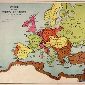
Mounted Print : Map / Europe / Balkans C1850


![]()
Mounted Prints from Mary Evans Picture Library
Map / Europe / Balkans C1850
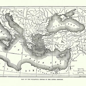
The Turkish-occupied territories in Europe, comprising all the Balkans apart from Greece
Mary Evans Picture Library makes available wonderful images created for people to enjoy over the centuries
Media ID 4342665
© Mary Evans Picture Library 2015 - https://copyrighthub.org/s0/hub1/creation/maryevans/MaryEvansPictureID/10046914
1850 Balkans C1850 Comprising Maps Occupied Territories
10"x8" Mount with 8"x6" Print
Discover the rich history of the Balkans in the 19th century with our stunningly detailed and authentic Mounted Photos from Media Storehouse. This particular image, sourced from Mary Evans Prints Online, captures the Turkish-occupied territories in Europe, encompassing all the Balkans apart from Greece around the year 1850. Each mounted photo is meticulously printed with high-quality, archival-grade inks on premium paper, ensuring your historical treasure remains vibrant and true to life. Bring history into your home or office with this captivating and intriguing piece.
Printed on 8"x6" paper and suitable for use in a 10"x8" frame (frame not included). Prints are mounted with card both front and back. Featuring a custom cut aperture to match chosen image. Professional 234gsm Fujifilm Crystal Archive DP II paper.
Photo prints supplied in custom cut card mount ready for framing
Estimated Image Size (if not cropped) is 14.7cm x 20.3cm (5.8" x 8")
Estimated Product Size is 20.3cm x 25.4cm (8" x 10")
These are individually made so all sizes are approximate
Artwork printed orientated as per the preview above, with portrait (vertical) orientation to match the source image.
FEATURES IN THESE COLLECTIONS
> Asia
> Turkey
> Related Images
> Europe
> Greece
> Related Images
> Europe
> Related Images
> Historic
> Ancient civilizations
> Ancient Greece
> Greek history
> Maps and Charts
> Early Maps
> Maps and Charts
> Related Images
EDITORS COMMENTS
This vintage map print from Mary Evans Prints Online showcases Europe in the year 1850, specifically focusing on the Balkans region which was predominantly under Turkish occupation at that time. The intricate details of this historical map provide a glimpse into the complex political landscape of the era, with all Balkan territories except Greece being controlled by the Ottoman Empire.
The borders and boundaries depicted on this map offer a visual representation of the power dynamics and territorial divisions that characterized Europe during this period. It serves as a reminder of the turbulent history of the Balkans, marked by centuries of conflict and conquest.
As we study this map, we are transported back in time to an era when empires vied for control over strategic regions like the Balkans. The names of cities and regions evoke images of ancient civilizations and long-forgotten battles that shaped the course of European history.
This print is not just a geographical representation but a window into a world where empires rose and fell, leaving behind legacies that continue to influence modern geopolitics. It is a testament to the enduring importance of understanding our past in order to navigate our present and future with wisdom and insight.
MADE IN THE UK
Safe Shipping with 30 Day Money Back Guarantee
FREE PERSONALISATION*
We are proud to offer a range of customisation features including Personalised Captions, Color Filters and Picture Zoom Tools
SECURE PAYMENTS
We happily accept a wide range of payment options so you can pay for the things you need in the way that is most convenient for you
* Options may vary by product and licensing agreement. Zoomed Pictures can be adjusted in the Basket.