Home > Europe > Germany > Maps
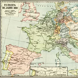
Europe in the mid-1500s

![]()
Wall Art and Photo Gifts from North Wind
Europe in the mid-1500s
Map of Europe during the early Protestant Reformation.
Printed color lithograph of a 19th-century illustration
North Wind Picture Archives brings history to life with stock images and hand-colored illustrations
Media ID 5882155
© North Wind Picture Archives
1500s 15th Century 16th Century Europe European Germany Mediterranean Mediterranean Sea Protestant Reformation Reformation
FEATURES IN THESE COLLECTIONS
> Maps and Charts
> Early Maps
> North Wind Picture Archives
> Maps
EDITORS COMMENTS
This print takes us back in time to Europe during the mid-1500s, a period marked by significant religious and political upheaval. The map showcases the continent's intricate borders, revealing the diverse nations and kingdoms that existed during this era of transformation. The vibrant colors used in this lithograph bring life to an illustration originally created in the 19th century, capturing the essence of European heritage and tradition. As we explore this piece of art, our eyes are drawn to Germany, where the Protestant Reformation was born. This movement, led by Martin Luther and other reformers, challenged the authority of the Catholic Church and forever altered Europe's religious landscape. The Mediterranean Sea dominates a large portion of this map, serving as a reminder of Europe's close ties with North Africa and Asia during these times. It also symbolizes trade routes that connected different cultures across continents. Through this historic depiction, we gain insight into how boundaries were defined centuries ago - some familiar names remain while others have faded away over time. This visual representation offers us a glimpse into both history and geography simultaneously. As we study every detail on this print from North Wind Picture Archives, it becomes clear that it is not just an ordinary map; it is a window into an era filled with intellectual ferment and societal change – truly a treasure for any history enthusiast or lover of vintage artwork.
MADE IN THE UK
Safe Shipping with 30 Day Money Back Guarantee
FREE PERSONALISATION*
We are proud to offer a range of customisation features including Personalised Captions, Color Filters and Picture Zoom Tools
SECURE PAYMENTS
We happily accept a wide range of payment options so you can pay for the things you need in the way that is most convenient for you
* Options may vary by product and licensing agreement. Zoomed Pictures can be adjusted in the Basket.