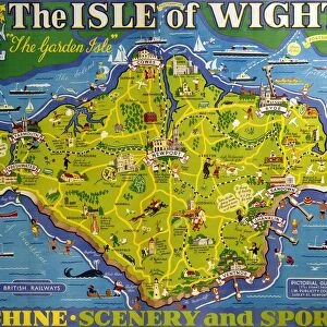
Mounted Print > Arts > Portraits > Pop art gallery > Street art portraits
Mounted Print : Amsterdam Plan


![]()
Mounted Prints From Mary Evans Picture Library
Amsterdam Plan
A pre-railway plan showing how the streets and canals have been built concentrically round the city centre. Date: mid-19th century
Mary Evans Picture Library makes available wonderful images created for people to enjoy over the centuries
Media ID 586882
© Mary Evans Picture Library 2015 - https://copyrighthub.org/s0/hub1/creation/maryevans/MaryEvansPictureID/10180195
10"x8" Mount with 8"x6" Print
Discover the rich history of Amsterdam with our stunningly detailed and beautifully preserved Mounted Photos from Media Storehouse. This particular piece features the mid-19th century Amsterdam Plan by Mary Evans Picture Library from Mary Evans Prints Online. Witness the intricate design of the city's streets and canals, meticulously built concentrically around the city centre, before the era of railways. Each Mounted Photo is meticulously printed on premium quality paper and mounted on sturdy foam core board, ensuring a long-lasting and vibrant display. Bring a piece of historical Amsterdam into your home or office, and transport yourself back in time with every captivating detail. Order yours today and start your collection!
Printed on 8"x6" paper and suitable for use in a 10"x8" frame (frame not included). Prints are mounted with card both front and back. Featuring a custom cut aperture to match chosen image. Professional 234gsm Fujifilm Crystal Archive DP II paper.
Photo prints supplied in custom cut card mount ready for framing
Estimated Image Size (if not cropped) is 20.3cm x 15cm (8" x 5.9")
Estimated Product Size is 25.4cm x 20.3cm (10" x 8")
These are individually made so all sizes are approximate
Artwork printed orientated as per the preview above, with landscape (horizontal) orientation to match the source image.
FEATURES IN THESE COLLECTIONS
> Arts
> Portraits
> Pop art gallery
> Street art portraits
> Popular Themes
> Railway Posters
EDITORS COMMENTS
This fascinating print showcases the mid-19th century Amsterdam Plan, revealing how the streets and canals were meticulously built concentrically around the city center. The intricate design of this historical map provides a glimpse into the urban development of Amsterdam before the introduction of railways.
The detailed layout highlights the strategic planning that went into creating a functional and aesthetically pleasing cityscape. Each street and canal is carefully mapped out, demonstrating a harmonious balance between form and function. It's clear that every aspect of this plan was thoughtfully considered to optimize transportation, commerce, and overall livability within Amsterdam.
As we study this pre-railway plan, we are transported back in time to an era when urban planning was both an art and a science. The concentric arrangement of streets and canals reflects a deep understanding of spatial organization and efficiency. It's truly remarkable to see how cities like Amsterdam were able to thrive even without modern transportation systems.
This print from Mary Evans Picture Library serves as a valuable historical document, shedding light on the evolution of urban landscapes in Europe. It's a reminder of the rich history behind our modern cities and how thoughtful planning has shaped their development over centuries.
MADE IN THE UK
Safe Shipping with 30 Day Money Back Guarantee
FREE PERSONALISATION*
We are proud to offer a range of customisation features including Personalised Captions, Color Filters and Picture Zoom Tools
SECURE PAYMENTS
We happily accept a wide range of payment options so you can pay for the things you need in the way that is most convenient for you
* Options may vary by product and licensing agreement. Zoomed Pictures can be adjusted in the Basket.