Mounted Print > Arts > Photorealistic artworks > Detailed art pieces > Masterful detailing in art
Mounted Print : Old Map of Southern Germany 1852 by Henry George Collins


![]()
Mounted Prints from MapSeeker
Old Map of Southern Germany 1852 by Henry George Collins
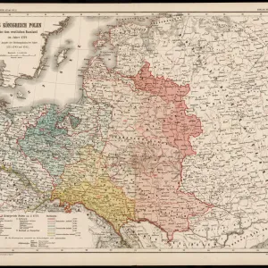
This is a finely detailed map of Southern Germany remastered from a rare Atlas of the World published in 1852 by Henry George Collins. Although these Henry Collins produced maps of the highest quality in his time unfortunately not the same could be said in terms of his business success. His maps were later obtained by the famous Stanford Map Company and used in their publications
Welcome to the Mapseeker Image library and enter an historic gateway to one of the largest on-line collections of Historic Maps, Nostalgic Views, Vista's and Panorama's from a World gone by.
Media ID 20347279
© Mapseeker Publishing Ltd
Collins Collins Atlas Collins Atlas Map Collins Map South Germany Southern Germany
10"x8" Mount with 8"x6" Print
Step back in time with our exquisite Mounted Photos featuring an Old Map of Southern Germany from 1852 by Henry George Collins, remastered from the rare Atlas of the World published by MapSeeker. This intricately detailed map showcases the historical landscape of Southern Germany during the mid-19th century. Each Mounted Photo is meticulously printed on premium photo paper and mounted on high-quality foam core board, creating a stunning and timeless piece for your home or office. Bring history to life with this captivating and unique addition to your decor.
Printed on 8"x6" paper and suitable for use in a 10"x8" frame (frame not included). Prints are mounted with card both front and back. Featuring a custom cut aperture to match chosen image. Professional 234gsm Fujifilm Crystal Archive DP II paper.
Photo prints supplied in custom cut card mount ready for framing
Estimated Image Size (if not cropped) is 20.3cm x 13.5cm (8" x 5.3")
Estimated Product Size is 25.4cm x 20.3cm (10" x 8")
These are individually made so all sizes are approximate
Artwork printed orientated as per the preview above, with landscape (horizontal) orientation to match the source image.
FEATURES IN THESE COLLECTIONS
> MapSeeker
> Maps of Europe
> Maps of Germany PORTFOLIO
> Arts
> Photorealistic artworks
> Detailed art pieces
> Masterful detailing in art
> Maps and Charts
> Related Images
> Maps and Charts
> World
EDITORS COMMENTS
This beautifully preserved print showcases an exquisite piece of cartographic history - the "Old Map of Southern Germany 1852" by Henry George Collins. Remastered from a rare Atlas of the World published in 1852, this map offers a fascinating glimpse into the geographical landscape of that era. Henry Collins was renowned for his exceptional craftsmanship and attention to detail, evident in every inch of this meticulously crafted map. Despite his undeniable talent, Collins faced unfortunate struggles when it came to business success. However, fate had other plans for these remarkable maps as they were later acquired by the prestigious Stanford Map Company and incorporated into their esteemed publications. The intricate details captured on this print provide a captivating visual journey through Southern Germany's past. From its vibrant cities to its sprawling countryside, one can trace the historical boundaries and landmarks that shaped this region during that time. Whether you are an avid historian or simply appreciate vintage cartography, this old map is sure to transport you back in time. Discovering Southern Germany through Henry George Collins' lens allows us to appreciate not only his artistic prowess but also gain insights into how our world has evolved over centuries
MADE IN THE UK
Safe Shipping with 30 Day Money Back Guarantee
FREE PERSONALISATION*
We are proud to offer a range of customisation features including Personalised Captions, Color Filters and Picture Zoom Tools
SECURE PAYMENTS
We happily accept a wide range of payment options so you can pay for the things you need in the way that is most convenient for you
* Options may vary by product and licensing agreement. Zoomed Pictures can be adjusted in the Basket.