Home > Arts > Photorealistic artworks > Detailed art pieces > Masterful detailing in art
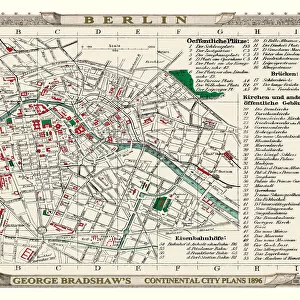
Old Map of Northern Germany 1852 by Henry George Collins

![]()
Wall Art and Photo Gifts from MapSeeker
Old Map of Northern Germany 1852 by Henry George Collins
This is a finely detailed map of Northern Germany remastered from a rare Atlas of the World published in 1852 by Henry George Collins. Although these Henry Collins produced maps of the highest quality in his time unfortunately not the same could be said in terms of his business success. His maps were later obtained by the famous Stanford Map Company and used in their publications
Welcome to the Mapseeker Image library and enter an historic gateway to one of the largest on-line collections of Historic Maps, Nostalgic Views, Vista's and Panorama's from a World gone by.
Media ID 20347291
© Mapseeker Publishing Ltd
Collins Collins Atlas Collins Atlas Map Collins Map North Germany Northern Germany
FEATURES IN THESE COLLECTIONS
> Arts
> Photorealistic artworks
> Detailed art pieces
> Masterful detailing in art
> Maps and Charts
> Related Images
> Maps and Charts
> World
> MapSeeker
> Maps of Europe
> Maps of Germany PORTFOLIO
EDITORS COMMENTS
This beautifully preserved print showcases an Old Map of Northern Germany from 1852, meticulously crafted by the talented cartographer Henry George Collins. Remastered from a rare Atlas of the World, this map offers a glimpse into the historical geography of the region during that era. Henry Collins was renowned for his exceptional map-making skills and his dedication to producing high-quality maps. However, despite his talent, he faced challenges in terms of business success. Fortunately, his remarkable maps were later acquired by the prestigious Stanford Map Company and incorporated into their publications. The level of detail captured in this map is truly impressive. It provides a comprehensive view of Northern Germany with intricate markings indicating cities, towns, rivers, and other geographical features. This vintage piece serves as both a decorative item and an educational tool for history enthusiasts or those interested in exploring Germany's past. Whether you are fascinated by cartography or simply appreciate the beauty of old-world craftsmanship, this Old Map of Northern Germany will surely captivate your imagination. Transport yourself back to 1852 as you trace the contours of ancient borders and envision how life might have been in this region centuries ago.
MADE IN THE UK
Safe Shipping with 30 Day Money Back Guarantee
FREE PERSONALISATION*
We are proud to offer a range of customisation features including Personalised Captions, Color Filters and Picture Zoom Tools
SECURE PAYMENTS
We happily accept a wide range of payment options so you can pay for the things you need in the way that is most convenient for you
* Options may vary by product and licensing agreement. Zoomed Pictures can be adjusted in the Basket.