Mounted Print > Europe > United Kingdom > Scotland > Strathclyde > Dumbarton
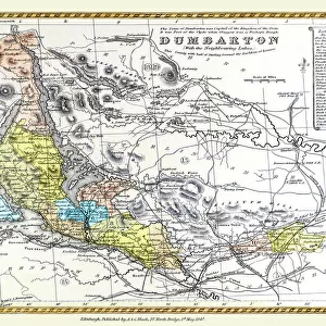
Mounted Print : Old Map of the County of Dumbarton from the Philips Handy Atlas of 1882


![]()
Mounted Prints from MapSeeker
Old Map of the County of Dumbarton from the Philips Handy Atlas of 1882
PHA008
Welcome to the Mapseeker Image library and enter an historic gateway to one of the largest on-line collections of Historic Maps, Nostalgic Views, Vista's and Panorama's from a World gone by.
Media ID 20348028
County Map County Map Of Scotland Historic Map Old County Map Old Scottish County Map Dumbarton Dumbartonshire Dunbartonshire
10"x8" Mount with 8"x6" Print
Step back in time with our stunning Mounted Photos from Media Storehouse. This particular piece features an Old Map of Dumbarton County from the Philips Handy Atlas of 1882, sourced from MapSeeker. Each Mounted Photo is meticulously printed on premium photo paper and mounted on a sturdy, acid-free backing to ensure longevity. The intricate details of the map are brought to life with vibrant colors and sharp lines, making it a captivating addition to any room. Transport yourself back to the late 19th century with this piece of historical art. Order yours today and add a touch of nostalgia to your home decor.
Printed on 8"x6" paper and suitable for use in a 10"x8" frame (frame not included). Prints are mounted with card both front and back. Featuring a custom cut aperture to match chosen image. Professional 234gsm Fujifilm Crystal Archive DP II paper.
Photo prints supplied in custom cut card mount ready for framing
Estimated Image Size (if not cropped) is 19cm x 15.2cm (7.5" x 6")
Estimated Product Size is 25.4cm x 20.3cm (10" x 8")
These are individually made so all sizes are approximate
Artwork printed orientated as per the preview above, with landscape (horizontal) orientation to match the source image.
FEATURES IN THESE COLLECTIONS
> MapSeeker
> Maps from the British Isles
> Scotland and Counties PORTFOLIO
> Europe
> United Kingdom
> Scotland
> Dumbarton
> Europe
> United Kingdom
> Scotland
> Maps
> Europe
> United Kingdom
> Scotland
> Strathclyde
> Dumbarton
> Maps and Charts
> Early Maps
> Maps and Charts
> Related Images
EDITORS COMMENTS
This print showcases an exquisite piece of history - the Old Map of the County of Dumbarton from the Philips Handy Atlas of 1882. Steeped in Scottish heritage, this vintage county map offers a glimpse into the past, transporting us to a bygone era. With intricate details and delicate craftsmanship, this old Scottish county map is a testament to the artistry and precision that went into cartography during that time. It beautifully captures the boundaries and landmarks of Dunbartonshire, providing a fascinating insight into its historical geography. As we explore this historic map, we are reminded of how landscapes have evolved over time. From bustling towns like Dumbarton to serene countryside dotted with villages and hamlets, every corner tells a story waiting to be discovered. The rivers winding through lush green valleys and mountains standing tall in their majestic glory evoke a sense of awe for nature's grandeur. This remarkable piece serves as more than just decorative wall art; it is an educational tool that sparks curiosity about our ancestors' lives and their connection to these lands. Whether you have ancestral ties or simply appreciate Scotland's rich cultural heritage, this old county map will undoubtedly transport you back in time
MADE IN THE UK
Safe Shipping with 30 Day Money Back Guarantee
FREE PERSONALISATION*
We are proud to offer a range of customisation features including Personalised Captions, Color Filters and Picture Zoom Tools
SECURE PAYMENTS
We happily accept a wide range of payment options so you can pay for the things you need in the way that is most convenient for you
* Options may vary by product and licensing agreement. Zoomed Pictures can be adjusted in the Basket.