Mounted Print > Maps and Charts > Americas
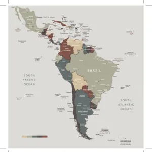
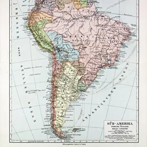
Mounted Print : Physical map of South America


![]()
Mounted Prints from Fine Art Storehouse
Physical map of South America
Vector illustration of the physical map of South America
Reference map was created by the US Central Intelligence Agency and is available as a public domain map at the University of Texas Libraries website
Unleash your creativity and transform your space into a visual masterpiece!
Media ID 15192870
14"x12" Mount with 12"x10" Print
Discover the beauty and intrigue of South America with our exquisite Mounted Photos from Media Storehouse. Featuring a stunning, high-resolution image of a physical map of South America, this piece is not just a decorative addition to your space, but a conversation starter. Meticulously crafted with museum-quality materials, this mounted photo boasts vibrant colors and exceptional detail, showcasing the diverse geography and rich cultural heritage of the continent. The map, created by the US Central Intelligence Agency and available as a public domain map at the University of Texas Libraries, adds an air of sophistication and worldliness to any room. Order yours today and bring a piece of the world into your home or office.
Printed on 12"x10" paper and suitable for use in a 14"x12" frame (frame not included). Prints are mounted with card both front and back. Featuring a custom cut aperture to match chosen image. Professional 234gsm Fujifilm Crystal Archive DP II paper.
Photo prints supplied in custom cut card mount ready for framing
Estimated Image Size (if not cropped) is 25.4cm x 25.4cm (10" x 10")
Estimated Product Size is 30.5cm x 35.6cm (12" x 14")
These are individually made so all sizes are approximate
Artwork printed orientated as per the preview above, with landscape (horizontal) or portrait (vertical) orientation to match the source image.
FEATURES IN THESE COLLECTIONS
> Fine Art Storehouse
> Map
> Reference Maps
> Maps and Charts
> Related Images
> South America
> Related Images
EDITORS COMMENTS
Discover the breathtaking beauty of South America through this stunning physical map print. With intricate details and vibrant colors, this vector illustration captures the diverse landscapes that make up this continent. From the majestic peaks of the Andes Mountains to the lush Amazon rainforest, every geographical feature is meticulously depicted. This reference map, created by the US Central Intelligence Agency and made available as a public domain map at the University of Texas Libraries website, offers an authentic representation of South America's topography. Whether you are an avid traveler or simply fascinated by geography, this artwork serves as both an educational tool and a visual delight. Immerse yourself in its rich tapestry as you trace your fingers along winding rivers like the mighty Amazon or explore coastal plains stretching for miles on end. Marvel at Patagonia's icy glaciers contrasting with Argentina's fertile pampas. Feel a sense of wonderment as you navigate through dense jungles teeming with exotic wildlife. Perfect for home decor or office spaces, this fine art print adds sophistication and intrigue to any setting. Let it transport you to far-off lands and ignite your wanderlust for adventure in one of Earth's most enchanting regions – South America.
MADE IN THE UK
Safe Shipping with 30 Day Money Back Guarantee
FREE PERSONALISATION*
We are proud to offer a range of customisation features including Personalised Captions, Color Filters and Picture Zoom Tools
SECURE PAYMENTS
We happily accept a wide range of payment options so you can pay for the things you need in the way that is most convenient for you
* Options may vary by product and licensing agreement. Zoomed Pictures can be adjusted in the Basket.