Mounted Print > North America > United States of America > New York > New York > Maps
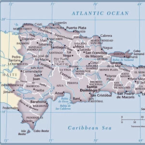
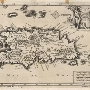
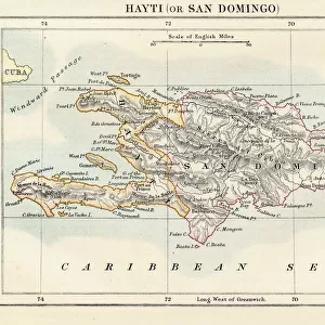
Mounted Print : Haiti and Dominican republic map 1883


![]()
Mounted Prints from Fine Art Storehouse
Haiti and Dominican republic map 1883
Encyclopedia Britannica 9th Edition New York Samuel L. Hall 1883 Vol XI
Unleash your creativity and transform your space into a visual masterpiece!
THEPALMER
Media ID 14756796
© This content is subject to copyright
Caribbean Sea Haiti Island Santo Domingo
10"x8" Mount with 8"x6" Print
Step back in time with our exquisite Mounted Photo featuring a captivating map of Haiti and the Dominican Republic from the Encyclopedia Britannica 9th Edition, published in New York in 1883 by Samuel L. Hall. Meticulously reproduced from the original ThePalmer atlas, this vintage map showcases intricate cartographic details and historical accuracy. Add an air of sophistication and worldly charm to your home or office decor with this stunning piece of cartographic history. Order now and travel back in time with every glance.
Printed on 8"x6" paper and suitable for use in a 10"x8" frame (frame not included). Prints are mounted with card both front and back. Featuring a custom cut aperture to match chosen image. Professional 234gsm Fujifilm Crystal Archive DP II paper.
Photo prints supplied in custom cut card mount ready for framing
Estimated Image Size (if not cropped) is 20.3cm x 14.8cm (8" x 5.8")
Estimated Product Size is 25.4cm x 20.3cm (10" x 8")
These are individually made so all sizes are approximate
Artwork printed orientated as per the preview above, with landscape (horizontal) orientation to match the source image.
FEATURES IN THESE COLLECTIONS
> Fine Art Storehouse
> Map
> Historical Maps
> Maps and Charts
> Related Images
> North America
> Dominican Republic
> Dominican Republic Heritage Sites
> Colonial City of Santo Domingo
> North America
> Dominican Republic
> Maps
> North America
> Dominican Republic
> Related Images
> North America
> Dominican Republic
> Santo Domingo
> North America
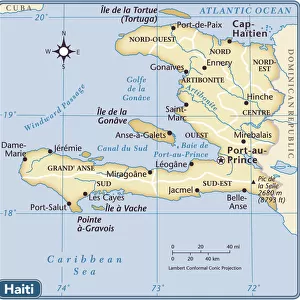
> Haiti
> Maps
> North America
> Haiti
> Related Images
> North America
> United States of America
> New York
> New York
> Maps
> North America
> United States of America
> New York
> Related Images
EDITORS COMMENTS
In this print titled "Haiti and Dominican Republic Map 1883" we are transported back in time to the late 19th century, where cartography was a meticulous art form. This particular piece is sourced from the Encyclopedia Britannica's 9th Edition, published in New York by Samuel L. Hall in 1883. The map showcases the beautiful islands of Haiti and the Dominican Republic nestled within the Caribbean Sea. With intricate details and precise markings, it provides a fascinating glimpse into the geographical landscape of these two nations during that era. As we examine this vintage map, our eyes are drawn to Santo Domingo, an important city on Hispaniola Island that has witnessed centuries of history unfold. The delicate lines trace rivers, mountains, and coastlines with remarkable accuracy—reminding us of how early explorers navigated these lands without modern technology. This print by THEPALMER captures not only historical significance but also serves as a visual testament to human curiosity and exploration. It invites us to reflect upon how boundaries have shifted over time while appreciating the enduring beauty of these Caribbean nations. Whether displayed in a study or gallery space, this artwork transports viewers back to an age when maps were cherished artifacts representing knowledge and discovery. Through its rich historical context and artistic presentation, "Haiti and Dominican Republic Map 1883" offers both educational value and aesthetic appeal for admirers of fine art prints.
MADE IN THE UK
Safe Shipping with 30 Day Money Back Guarantee
FREE PERSONALISATION*
We are proud to offer a range of customisation features including Personalised Captions, Color Filters and Picture Zoom Tools
SECURE PAYMENTS
We happily accept a wide range of payment options so you can pay for the things you need in the way that is most convenient for you
* Options may vary by product and licensing agreement. Zoomed Pictures can be adjusted in the Basket.