Antique Framed Print > North America > United States of America > New York > New York > Maps
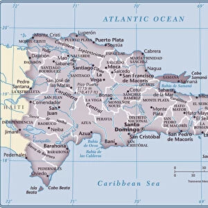
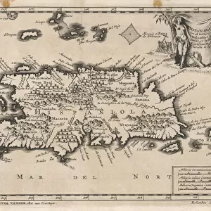
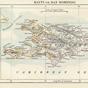
Antique Framed Print : Haiti and Dominican republic map 1883


![]()
Framed Photos from Fine Art Storehouse
Haiti and Dominican republic map 1883
Encyclopedia Britannica 9th Edition New York Samuel L. Hall 1883 Vol XI
Unleash your creativity and transform your space into a visual masterpiece!
THEPALMER
Media ID 14756796
© This content is subject to copyright
Caribbean Sea Haiti Island Santo Domingo
14"x12" (36x31cm) Antique Frame
Bevelled wood effect frame, card mounted, 10x8 archival quality photo print. Overall outside dimensions 14x12 inches (36x31cm). Environmentally and ozone friendly, the Polycore® moulding has the look of real wood, is durable and light and easy to hang. Biodegradable and made with non-chlorinated gases (no toxic fumes) it is efficient; producing 100 tons of polystyrene can save 300 tons of trees! Prints are glazed with lightweight, shatterproof, optical clarity acrylic (providing the same general protection from the environment as glass). The back is stapled hardboard with a sawtooth hanger attached. Note: To minimise original artwork cropping, for optimum layout, and to ensure print is secure, the visible print may be marginally smaller
Bevelled Wood Effect Framed and Mounted Prints - Professionally Made and Ready to Hang
Estimated Image Size (if not cropped) is 24.4cm x 17.7cm (9.6" x 7")
Estimated Product Size is 36.3cm x 31.2cm (14.3" x 12.3")
These are individually made so all sizes are approximate
Artwork printed orientated as per the preview above, with landscape (horizontal) orientation to match the source image.
FEATURES IN THESE COLLECTIONS
> Maps and Charts
> Related Images
> North America
> Dominican Republic
> Dominican Republic Heritage Sites
> Colonial City of Santo Domingo
> North America
> Dominican Republic
> Maps
> North America
> Dominican Republic
> Related Images
> North America
> Dominican Republic
> Santo Domingo
> North America
> Haiti
> Maps
> North America
> Haiti
> Related Images
> North America
> United States of America
> New York
> New York
> Maps
> North America
> United States of America
> New York
> Related Images
> Fine Art Storehouse
> Map
> Historical Maps
EDITORS COMMENTS
In this print titled "Haiti and Dominican Republic Map 1883" we are transported back in time to the late 19th century, where cartography was a meticulous art form. This particular piece is sourced from the Encyclopedia Britannica's 9th Edition, published in New York by Samuel L. Hall in 1883. The map showcases the beautiful islands of Haiti and the Dominican Republic nestled within the Caribbean Sea. With intricate details and precise markings, it provides a fascinating glimpse into the geographical landscape of these two nations during that era. As we examine this vintage map, our eyes are drawn to Santo Domingo, an important city on Hispaniola Island that has witnessed centuries of history unfold. The delicate lines trace rivers, mountains, and coastlines with remarkable accuracy—reminding us of how early explorers navigated these lands without modern technology. This print by THEPALMER captures not only historical significance but also serves as a visual testament to human curiosity and exploration. It invites us to reflect upon how boundaries have shifted over time while appreciating the enduring beauty of these Caribbean nations. Whether displayed in a study or gallery space, this artwork transports viewers back to an age when maps were cherished artifacts representing knowledge and discovery. Through its rich historical context and artistic presentation, "Haiti and Dominican Republic Map 1883" offers both educational value and aesthetic appeal for admirers of fine art prints.
MADE IN THE UK
Safe Shipping with 30 Day Money Back Guarantee
FREE PERSONALISATION*
We are proud to offer a range of customisation features including Personalised Captions, Color Filters and Picture Zoom Tools
SECURE PAYMENTS
We happily accept a wide range of payment options so you can pay for the things you need in the way that is most convenient for you
* Options may vary by product and licensing agreement. Zoomed Pictures can be adjusted in the Basket.